Ancient Mediterranean Shipyards and Harbours

Bronze Age Rhodes and the Evolution of Eastern Mediterranean Trade Networks, c. 1700 BCE – 1200 BCE

By Nick Nutter | Published: 2026-05-21 | Updated: 2026-07-17

Visited 559 times

Situated at the crossroads of the Aegean, Anatolia, and the Levant, the island of Rhodes functioned as a vital maritime conduit during the Late Bronze Age (c. 1700–1200 BCE). Rhodes operated as a decentralised tripartite coalition comprising the coastal centres of Ialysos, Kamiros, and Lindos. This maritime network facilitated the movement of Cypriot copper, Aegean ceramics, and cultural influence between Minoan, Mycenaean (Ahhiyawan), and Near Eastern spheres. This decentralised political and economic structure explains why Rhodes demonstrated remarkable resilience during the Late Bronze Age Collapse, successfully sustaining long-distance eastern trade networks as mainland palatial economies fragmented into the Early Iron Age.

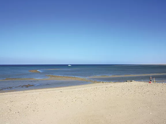
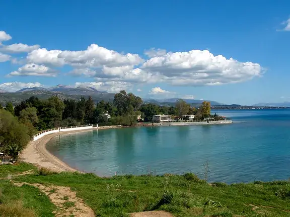
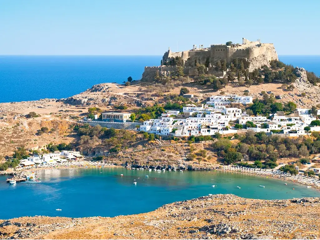
Bronze Age Rhodes and the Evolution of Eastern Mediterranean Trade Networks, c. 1700 BCE – 1200 BCE - The sheltered bay at Lindos
The sheltered bay at Lindos

Strategic Geography: Rhodes as a Maritime Crossroads in the Ancient Mediterranean

The ancient Mediterranean depended on sea routes that linked many different societies in an early form of international trade. Rhodes was part of this system because of where it was located. The island sits at the southeastern edge of the Aegean Sea, close to the coast of Anatolia (modern-day Turkey), and helped connect the Aegean with the Levant, Egypt, and Cyprus (Broodbank, 2013).

The city of Rhodes itself did not yet exist in the Bronze Age, when bronze was the main material used for tools and weapons before iron became widespread. The unified capital was created much later, in 408/407 BCE, through a political union known as synoecism (Gabrielsen, 1997). Before that later city existed, the island’s importance can be traced through scattered written clues and archaeological evidence.

Epigraphic Evidence: Hittite Ahhiyawa, Linear B, and the Earliest Naming of Rhodes

One of the earliest possible clues comes from the world of the Hittites and Mycenaeans. To the Hittites, the island of Rhodes and its Mycenaean inhabitants seem to have belonged to a wider western world they called Ahhiyawa (Beckman, Bryce and Cline, 2025). The earliest possible written reference to Rhodes may appear in Linear B tablets found at the Mycenaean palace of Pylos, on the Greek mainland. These tablets were administrative records, and they list groups of state-owned workers, including captive or enslaved women from the eastern Aegean and the Anatolian coast. One term in the tablets is ro-de-ja, sometimes also discussed as ro-di-ja. Many scholars interpret it as meaning “Rhodian women,” or women from Rhodes. That reading fits well with other place names recorded at Pylos, including Miletus, Knidos, and Lemnos (Ventris and Chadwick, 1973).

If this interpretation is correct, the tablets would preserve the earliest known written reference to Rhodes, sometime between 1400 and 1200 BCE. However, the evidence is not certain. Linear B can be difficult to interpret, and the word for Rhodes is linked linguistically with the ancient Greek word for “rose” (rhodon, or Mycenaean wo-ro-do). For that reason, some scholars suggest the term could instead refer to women connected with rose gardens or the production of rose-scented oil, rather than to women from the island itself (Ventris and Chadwick, 1973). Whether or not this term names Rhodes directly, it points to the island’s place within the wider Aegean world.

Homeric Topography: The Tripartite Coalition of Rhodes in the Iliad's Catalogue of Ships

The first firm, unambiguous appearance of the name "Rhodes" (Ῥόδος - Rhodos) is in Book 2 of the Iliad. In the famous "Catalogue of Ships," the text describes the Greek forces sailing to Troy written during the 8th Century BCE:

"And Tlepolemus, the brave and tall son of Heracles, led from Rhodes nine ships of the proud Rhodians, those who dwelt in Rhodes apportioned among three domains: Lindos, Ialysos, and gleaming Kamiros." (Homer, Iliad, 2.653–656)

Although the Iliad was written down centuries after the Late Bronze Age Collapse, many historians see the Catalogue of Ships as a fossilised piece of oral tradition that may preserve older Bronze Age political geography (Hope Simpson and Lazenby, 1970). Its description of Rhodes as a three-part coalition, rather than a single unified capital, fits closely with the island’s archaeological record. This literary picture therefore prepares the ground for looking more closely at the three coastal centres themselves.

Together, Ialysos, Kamiros, and Lindos show how Rhodes developed its economic strength, linking the movement of goods with the exchange of technologies and cultural ideas across the eastern Mediterranean (Georgiadis, 2003).

Aegean Economic Integration: Minoan Origins and the Shift to Mycenaean Maritime Trade

During the Bronze Age, the island relied on a loose network of three main coastal centres: Ialysos, Kamiros, and Lindos. These centres first took part in Minoan trade networks. Later, after the eruption of the volcano Thera on Santorini between 1627 and 1600 BCE (Manning, 2022), Mycenaean influence became stronger, turning Rhodes into a major maritime crossroads with thriving glass, metal, and pottery industries (Benzi, 1992).

The Decentralised Coastal Network: Archaeological Evidence at Ialysos, Kamiros, and Lindos

Each of the three coastal settlements contributed something different to the island’s maritime economy.

Ialysos (Trianda): Minoan Influence and Mycenaean Mercantile Hub

Trianda, near modern Ialysos on the northern coast, is the best-excavated Bronze Age harbour on Rhodes. By around 1700 BCE, as the island entered the Late Bronze Age, the final part of the Bronze Age in the overall Aegean, lasting roughly from about 1700 BCE to 1200 BCE (note that the Bronze Age lasted another 150 years on Rhodes itself because Rhodes successfully rode out the general civilisation collapse around 1200 BCE), Trianda had already become one of Rhodes’s main sea-trading centres. At first, it was strongly shaped by Minoan culture. Later, it became a centre for Mycenaean merchants (Benzi, 1992). Through harbours such as Trianda, Aegean pottery, including the widely exported stirrup jars used to hold perfumed oils, was sent east. In return, Cypriot copper and tin moved west, providing key materials for metalworking (Tournavitou, 1992). The large amount of Mycenaean luxury goods moving through these networks shows how extensive Aegean sea trade was at this time (Bachhuber, 2006).

Kamiros: Agricultural Wealth and the Kalavarda Mycenaean Cemetery

Kamiros, on the northwestern coast, worked alongside Ialysos as a farming and trading centre. Its early history is shown by the Mycenaean cemetery near the modern village of Kalavarda, where archaeologists have found chamber tombs from the Late Helladic (LH) III periods, archaeological phases used to date Mycenaean Greece and nearby regions in the later Bronze Age (Georgiadis, 2003). These tombs contained valuable grave goods, showing that Kamiros was closely connected to the wider material culture of the Aegean. Its agricultural wealth gave the settlement a strong economic base and helped support trade with mainland Greece and Anatolia.

Lindos: Navigational Waypoint and the Pylona Late Helladic Tombs

On the eastern coast, Lindos, with its sheltered bay, was a prominent stopping point for sailors. Although its best-known buildings surviving today belong to the later Archaic and Hellenistic acropolis, the surrounding southeastern area has extensive Late Bronze Age burial evidence. This includes LH III chamber tombs at nearby Pylona, which place the area clearly within the Mycenaean world (Karantzali, 2001; Georgiadis, 2003). Taken together, these three centres made Rhodes a key link in long-distance trade and raise an important question: how was such an island network governed?

Mycenaean Political Geography: Rhodes and the Hittite Ahhiyawa Debate

Scholars continue to debate how Rhodes was governed during the Late Bronze Age. This question is closely linked to a larger debate about Mycenaean political power. Hittite diplomatic texts from the 15th to 13th centuries BCE often refer to a powerful western state called ‘Ahhiyawa’, a name many scholars connect with the Mycenaean Greek world (Beckman, Bryce and Cline, 2025).

Even so, scholars do not agree on exactly what Ahhiyawa was or how far its power reached. The Mycenaean world may have been a single empire ruled by one ‘Great King’, or it may have been a loose group of separate palace states. Because of this uncertainty, Rhodes’s political position is also unclear. Some scholars think Rhodes may have been an independent kingdom that managed its own relationships. Others argue that it was a frontier area or dependent territory under the control of mainland Ahhiyawa (Mountjoy, 1998; Beckman, Bryce and Cline, 2025).

The Homeric tradition, which may preserve memories of Bronze Age politics, also reflects this mixed picture. In the Iliad’s Catalogue of Ships, Rhodes is described as united under Tlepolemus, but it is also divided into three separate areas: Ialysos, Lindos, and Kamiros. This suggests that Rhodes may have worked as a three-part coalition: an island with a shared culture, but with political life organised around three main centres rather than one central palace. This flexible political and economic structure became especially important when the eastern Mediterranean entered a period of crisis around 1200 BCE.

Regional Resilience: Rhodes During the Late Bronze Age Collapse (c. 1200 BCE)

These trade networks and political systems faced serious pressure around the start of the 12th century BCE, meaning the period from 1200 BCE to 1101 BCE. This period is usually called the Late Bronze Age Collapse, a time when several major eastern Mediterranean palace systems broke down (Cline, 2014). During it, most, but not all, the palace societies of mainland Greece were destroyed or abandoned. At the same time, the Hittite Empire broke apart, and major centres in the Levant came under attack (Dickinson, 2006).

Rhodes seems to have followed a different path from many mainland centres. Instead of being fully caught up in the destruction, the island appears to have entered a period of population growth and economic activity. Once it was no longer closely tied to the centralised palace economies of the mainland, the separate centres of Ialysos, Kamiros, and Lindos proved flexible and resilient. They continued to maintain sea links with surviving eastern outposts, showing that Rhodian trade networks could endure even during a wider regional crisis (Benzi, 1992; Dickinson, 2006).

Further Reading on Rhodian History

References and Further Reading

  • Bachhuber, C. (2006). Aegean Interest on the Uluburun Ship. American Journal of Archaeology, 110(3), 345–363.
  • Beckman, G., Bryce, T., & Cline, E. H. (2025). The Ahhiyawa Texts. SBL Press.
  • Benzi, M. (1992). Rodi e la civiltà micenea. Gruppo Editoriale Internazionale.
  • Broodbank, C. (2013). The Making of the Middle Sea: A History of the Mediterranean from the Beginning to the Emergence of the Classical World. Thames & Hudson.
  • Cline, E. H. (2014). 1177 B.C.: The Year Civilization Collapsed. Princeton University Press.
  • Dickinson, O. (2006). The Aegean from Bronze Age to Iron Age: Continuity and Change Between the Twelfth and Eighth Centuries BC. Routledge.
  • Gabrielsen, V. (1997). The Naval Aristocracy of Hellenistic Rhodes. Aarhus University Press.
  • Georgiadis, M. (2003). The South-Eastern Aegean in the Mycenaean Period: Islands, landscape, death and ancestors. Archaeopress.
  • Hope Simpson, R., & Lazenby, J. F. (1970). The Catalogue of the Ships in Homer's Iliad. Clarendon Press.
  • Karantzali, E. (2001). The Mycenaean Cemetery at Pylona on Rhodes. Archaeopress.
  • Manning, S. W. (2022). Second Intermediate Period date for the Thera (Santorini) eruption and historical implications. PLOS ONE, 17(9), e0274835.
  • Mountjoy, P. A. (1998). The East Aegean-West Anatolian Interface in the Late Bronze Age: Mycenaeans and the Kingdom of Ahhiyawa. Anatolian Studies, 48, 33–67.
  • Tournavitou, I. (1992). Practical use and social function: a neglected aspect of Mycenaean pottery. The Annual of the British School at Athens, 87, 181–210.
  • Ventris, M., & Chadwick, J. (1973). Documents in Mycenaean Greek (2nd ed.). Cambridge University Press.

Location Map

Legacy Reloaded: A dev, an AI, and the relentless pursuit of 100

Enjoying this clean, uncluttered read?

You are currently browsing the result of a massive technical overhaul. My new book, Legacy Reloaded: A dev, an AI, and the relentless pursuit of 100, chronicles the journey of transforming an aging legacy website into a modern, lightning-fast platform that hits the perfect 90+, 100, 100, 100, 3/3 Lighthouse metrics. It’s a story of collaboration between developer and AI, and the stubborn pursuit of technical perfection.

Read the Story

You have finished reading chapter 8

More articles in the Ancient Mediterranean Shipyards and Harbours series: