Ancient Mediterranean Shipyards and Harbours
The Sunken Port of Kenchreai and the Incredible Diolkos
By Nick Nutter | Published: 2026-04-24 | Updated: 2026-05-17
Visited 1,361 times
Ancient Corinth had two massive, port cities, Kenchreai and Lechaion on either side of the Isthmus of Corinth. The two ports were connected by a roadway, the Diolkos, along which ships were hauled, thus avoiding a long haul round the Peloponnesian Peninsula.
Contents
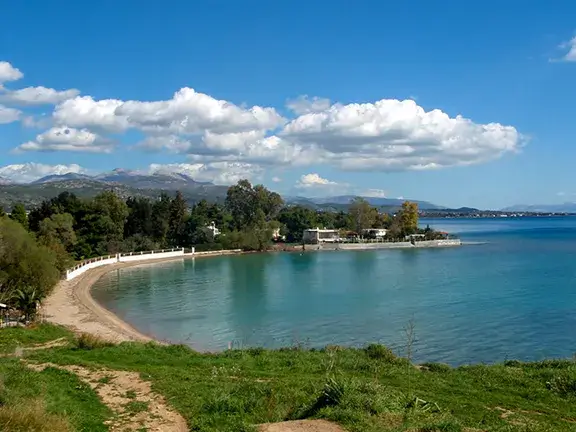
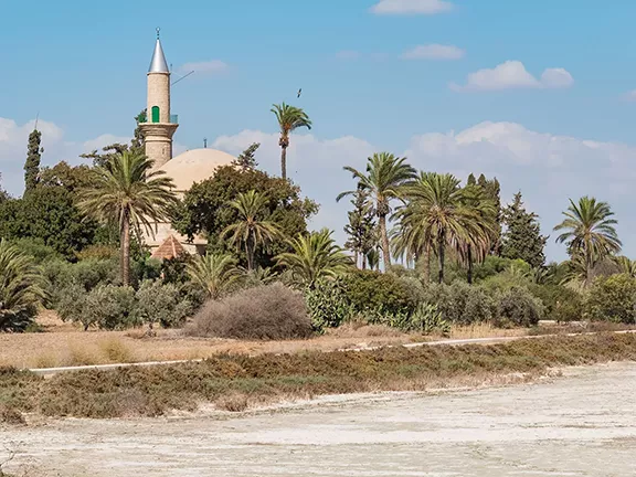
The Sunken Port of Kenchreai c 600 BC - 650 AD
Development of Kenchreai
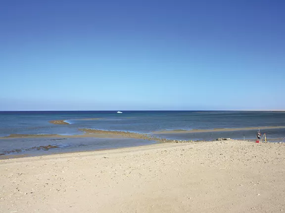
These ports were located approximately six kilometres apart on opposite sides of the Isthmus of Corinth, with Kenchreai situated to the east and Lechaion to the west. Kenchreai managed Greek mercantile trade in the eastern Mediterranean, while Lechaion focused on the Ionian Sea and the Greek colonies to the west. Traveling by sea between these ports required a journey of 185 nautical miles around the Peloponnese Peninsula, including passage past the notorious Cape Malea.
The geographer Strabo recorded a famous ancient Greek proverb: "Before you double Cape Malea, forget your home." It was considered one of the most dangerous navigational hazards in the Mediterranean.
The cape plays a pivotal role in Greek mythology. In the Odyssey, Odysseus is attempting to round Cape Malea to return home to Ithaca, but a fierce north wind blows his ships entirely off course, beginning his decade-long struggle to get home.
The Diolkos (The Overland Ship Trackway)
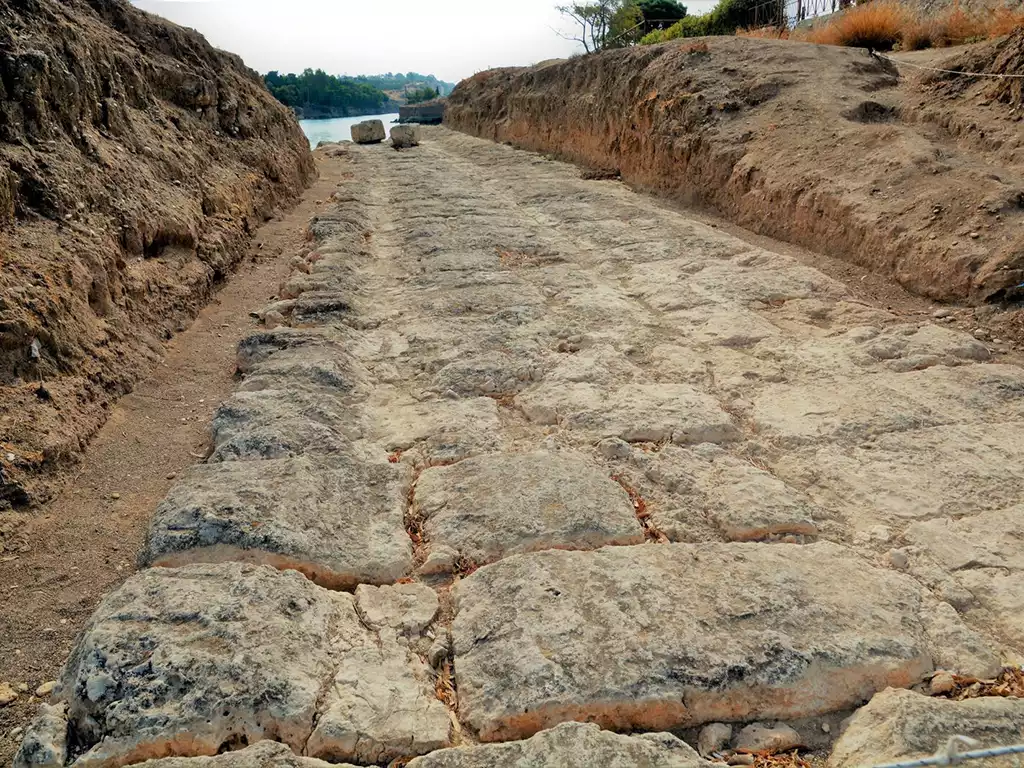
By creating a paved railway-style track across the Isthmus of Corinth, the Diolkos allowed ancient mariners to bypass the risky sea voyage around the Peloponnesian peninsula, saving them days of travel and immense risk.
The Route and Termini
The Diolkos spanned the roughly six-to-eight-kilometre width of the Isthmus, but it did not run in a perfectly straight line. Engineers designed the track to follow the natural contours of the land, keeping the gradient as shallow as possible (never exceeding a 1.5% incline) to ease the massive burden of hauling ships uphill.
In relation to Corinth's twin ports, the Diolkos acted as the terrestrial bridge between their respective gulfs:
The Eastern Terminus (Near Kenchreai): The trackway began on the shores of the Saronic Gulf. While Kenchreai was the primary commercial port handling the massive cargo ships, the actual starting point of the Diolkos was located just a few kilometres north of Kenchreai at a coastal settlement called Schoinous (near modern Kalamaki). This provided a slightly flatter, more direct starting gradient for the overland haul, while still keeping the operation strictly within Kenchreai's administrative and defensive sphere.
The Western Terminus (At Lechaion): The trackway snaked westward across the isthmus and terminated directly on the Corinthian Gulf, right beside the massive naval and industrial port of Lechaion.
Engineering and Design
The Diolkos was a highly sophisticated, paved trackway that effectively functioned as the world's first railway.
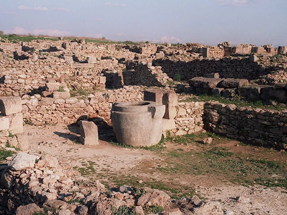
Limestone Paving: The road was constructed using massive blocks of hard limestone, creating a stable, durable surface that wouldn't sink into the mud under the immense weight of naval vessels.
The Guide Grooves: The most brilliant feature of the Diolkos was a pair of deep, parallel grooves cut directly into the stone paving, set about 1.5 metres apart.
The Olkos: These grooves were designed to guide the wheels of a massive, custom-built wooden carriage known as an olkos. Because the wheels were locked into the stone grooves, the carriage could not veer off the path or slide sideways, even when carrying top-heavy ships around the sweeping curves of the isthmus.
Operational Logistics: How to Haul a Ship
Moving a ship across the Diolkos was a colossal logistical undertaking, managed and heavily taxed by the Corinthian state.
Unloading: Heavy merchant vessels (which were too heavy and structurally fragile to be lifted out of the water fully loaded) would pull into the docks at Kenchreai or Lechaion. Workers would completely offload the cargo and the heavy masts.
Separate Transport: The cargo was loaded onto standard ox-carts and driven across the isthmus via regular roads.
Hoisting the Hull: The empty, lightened hull of the ship was towed to the Diolkos terminus, hoisted out of the water using wooden ramps and cranes, and strapped securely onto the massive olkos carriage. (Smaller naval warships, like triremes, could often be hauled without needing to be fully stripped).
Haul: Teams of draft animals (oxen or mules) and hundreds of enslaved labourers or paid workers would attach thick hemp ropes to the carriage and begin the slow, grinding pull across the six-kilometre track.
Relaunching: Upon reaching the opposite gulf, the ship was slid back into the water, the cargo was reloaded from the ox-carts, and the vessel continued its journey.
Through this ingenious system, Corinth effectively controlled the flow of east-west maritime traffic in the Mediterranean for centuries, taxing every single vessel and crate of cargo that crossed their stone railway.
An Ancient Emporion
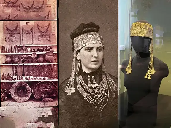
The port played a significant role in the early development of Christianity and offers a noteworthy, though frequently underappreciated, historical detail. The Apostle Paul is documented to have fulfilled a vow by cutting his hair at Kenchreai, while the local church was associated with Phoebe, a distinguished deacon. Both historical and biblical sources suggest that Phoebe transported Paul’s Epistle to the Romans from Kenchreai to Rome. In delivering the letter, Phoebe is regarded by scholars as the initial interpreter of one of Christianity's foundational texts, having addressed inquiries from the Roman congregation and clarified Paul's theological arguments upon her arrival.
The Cataclysm of AD 365
The sea advanced, submerging the harbour installations and the Temple of Isis. This event resulted in a unique underwater repository. When the temple was flooded, crates containing rare opus sectile glass panels, complex and colourful artworks produced for the temple's renovation, were sealed beneath the water. The abrupt inundation prevented theft of these valuable artefacts, facilitating their preservation until contemporary archaeologists recovered them from the seabed.
Modern Superyachts and Autonomous Research
In an innovative method for conducting historical research, scientific organizations are collaborating with the 'Yachts for Science' initiative. Private owners contribute their superyachts to serve as mobile research laboratories. Marine scientists use these platforms to deploy Remotely Operated Vehicles (ROVs) and sophisticated sonar mapping technologies. Such equipment enables the precise identification of submerged moles and shipwrecks, allowing for comprehensive mapping of ancient structures while maintaining the integrity of the aquatic environment.
Tracing the Trade and Timeline of Kenchreai
Establishing the Architectural Chronology of Kenchreai
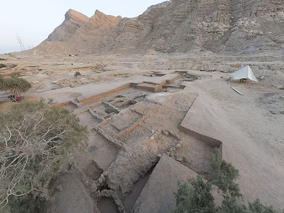
While Corinth established Kenchreai as a strategically important eastern port during the Archaic and Classical periods, later construction heavily obscures these early Greek foundations. The structural evidence visible to marine archaeologists today primarily dates to the Roman Imperial era, a period of massive investment and engineering prowess.
The Early Imperial Expansion (1st Century AD): After Julius Caesar re-established Corinth in 44 BC, Roman engineers undertook significant modifications to Kenchreai to support increased maritime activity. Construction teams implemented the northern and southern breakwaters (moles), utilising opus caementicium, a robust Roman concrete specifically designed to harden underwater. During the Antonine era in the 2nd Century AD, the harbour attained its architectural peak under the direction of imperial administrators. The moles were extended to nearly encircle the bay, creating secure docking for large grain vessels.
The Antonine Peak (AD 96–192): The harbour reached its architectural zenith during the Antonine dynasty. During this period, Roman engineers constructed extensive horseshoe-shaped breakwaters that rose thirty metres above the seabed. These stone structures protected the bay and facilitated the reception of merchant vessels importing wine, spices, and other goods from Egypt, Asia Minor, and the Levant. During this era, wealthy patrons funded the construction of the huge warehouses, the brick-faced commercial buildings on the northern mole, and the prominent sanctuaries, including the Temple of Isis.
Late Antique Modifications (3rd to 4th Centuries AD): Stratigraphic evidence demonstrates continued utilisation and alteration of these structures through to the late fourth century. During this period, residents undertook repairs to floors, reconstructed warehouse walls, and adjusted religious spaces, persisting until the major seismic events of AD 365 and AD 375 caused the principal harbour installations to collapse into the Saronic Gulf.
Analysing the Export Economy
Kenchreai functioned not only as a recipient of goods but also as an exporter of Peloponnesian products destined for the prosperous markets of the eastern Mediterranean. Archaeologists primarily identify these exports through the analysis of transport container remains.
Corinthian Amphorae: Excavations across the Aegean and the Levant frequently uncover distinctively shaped Corinthian transport amphorae. Merchants packed these heavy clay jars with locally produced olive oil and regional wines, shipping them outward from Kenchreai’s docks.
Manufactured Goods and Bronze: Corinth famously produced highly desirable metalwork, particularly 'Corinthian bronze', an alloy renowned for its lustrous patina. Traders funnelled these luxury manufactured goods, along with fine local pottery, through Kenchreai to wealthy buyers in Asia Minor and Egypt.
Cataloguing the Imports
The archaeological evidence at Kenchreai demonstrates its role as a cosmopolitan receiving port. Artefacts recovered from submerged warehouses and sanctuaries indicate substantial dependence on eastern trade networks.
Egyptian Grain: The continuity of the Roman colony at Corinth was wholly reliant on substantial deliveries of grain. Although bulk grain typically leaves minimal archaeological evidence in underwater contexts, the impressive size of the Antonine warehouses situated on Kenchreai's northern mole provides tangible proof of the extensive agricultural imports originating from Alexandria.
Exotic Raw Materials and Glass: The renowned opus sectile glass panels discovered beneath the Temple of Isis offer substantial evidence of specialised trade networks. Chemical analyses indicate that manufacturers sourced raw materials directly from Egypt and the Syro-Palestinian coast.
Fine Wares and Luxury Stone: The ceramic record indicates a prevalence of Eastern Sigillata, a high-quality red-slip tableware imported from the eastern Mediterranean. Additionally, architects incorporated coloured marbles sourced from the Greek islands and Asia Minor in the construction of civic and religious edifices, demonstrating Kenchreai's significant engagement with luxury architectural materials.
Chronological History of Kenchreai c 600 BC - 650 AD
By taking all the evidence gleaned from archaeological investigations from the initial discovery of Kenchrai in 1962 right through to the modern day, it is possible to create a detailed timeline for the port.
Archaic and Classical Foundations (c. 7th Century BC – 146 BC)
c. 7th Century BC: The city-state of Corinth officially establishes Kenchreai as its primary eastern harbour, seeking to dominate maritime trade across the Aegean Sea.
c. 600 BC: Engineers from Corinth developed the Diolkos, a paved overland route traversing the Isthmus. This advancement enabled the transfer of ships between the Saronic and Corinthian gulfs, thereby establishing Kenchreai as an essential transit hub.
5th – 4th Century BC: Kenchreai functions as a militarised naval base during the Peloponnesian War and subsequent Greek conflicts. The port shelters Corinthian fleets and facilitates rapid troop deployments.
146 BC: Roman forces under the command of Lucius Mummius sack and destroy ancient Corinth. The invasion severely disrupts regional trade networks, leaving Kenchreai largely abandoned and commercially stagnant for a century.
Roman Resurgence and the Golden Age (44 BC – AD 192)
44 BC: Julius Caesar refounds Corinth as a Roman colony (Colonia Laus Iulia Corinthiensis). Roman administrators immediately revitalise Kenchreai to re-establish the vital grain and luxury trade routes from the East.
1st Century AD: Builders construct the first major Roman moles using hydraulic concrete, significantly expanding the harbour's capacity and protecting merchant vessels from the often violent Saronic storms.
c. AD 51 – 52: The Apostle Paul resides in Corinth and eventually departs from Kenchreai for Syria. He famously cuts his hair at the port to fulfil a religious vow, and the harbour town establishes an early Christian community led by the deacon Phoebe. 2nd Century AD (The Antonine Peak): The harbour experiences its greatest prosperity under the Antonine dynasty. Wealthy patrons and imperial engineers construct massive brick-faced warehouses, the prominent Temple of Isis on the southern mole, and the Sanctuary of Aphrodite on the northern mole. The Greek travel writer Pausanias visits and formally documents the port's magnificent architecture.
Cataclysm, Adaptation, and Final Demise (AD 300 – 7th Century AD)
AD 365 and AD 375: Massive seismic events shatter the Peloponnese. Tectonic subsidence violently drops the coastline by up to two metres. The sea instantly swallows the primary harbour installations, the moles, and the sanctuaries, perfectly preserving a cache of opus sectile glass panels within the drowned Temple of Isis.
5th – 6th Century AD: The harbour never recovers its former commercial glory, but a diminished population remains. A resilient Christian community builds a basilica directly over the ruins of the submerged Isis sanctuary, adapting the surviving southern mole for religious gatherings rather than major trade.
Late 6th – Early 7th Century AD: Invasions by Slavic and Avar tribes destabilise the Greek peninsula. These incursions, combined with shifting Byzantine trade routes and further minor coastal changes, sever the remaining economic lifelines.
Mid-7th Century AD: The last residents abandon the site entirely. Silt and sea completely reclaim the ancient structures, burying Kenchreai until modern marine archaeologists begin unlocking its submerged secrets in the twentieth century.
References and Further Reading
To support the architectural history, the construction of the Roman breakwaters, and the relationship between Corinth, Kenchreai, and the Diolkos trackway:
Engels, D. (1990) Roman Corinth: An Alternative Model for the Classical City. Chicago: University of Chicago Press.
Scranton, R.L., Shaw, J.W. and Ibrahim, L. (1978) Kenchreai, Eastern Port of Corinth. I. Topography and Architecture. Leiden: E.J. Brill.
Wiseman, J. (1978) The Land of the Ancient Corinthians. Gothenburg: Paul Åströms Förlag.
The Diolkos
MacDonald, Brian R. (1986) 'The Diolkos', The Journal of Hellenic Studies, 106, pp. 191–195.
Pettegrew, David K. (2011) 'The Diolkos of Corinth', American Journal of Archaeology, 115(4), pp. 549–574.
Salmon, J. B. (1984) Wealthy Corinth: A History of the City to 338 BC. Oxford: Clarendon Press.
Werner, Walter (1997) 'The largest ship trackway in ancient times: the Diolkos of the Isthmus of Corinth, Greece, and early attempts to build a canal', The International Journal of Nautical Archaeology, 26(2), pp. 98–119.
A Cosmopolitan Hub of Antiquity
For information regarding the demographics, the Sanctuary of Isis, and the historical/biblical scholarship surrounding the Apostle Paul and Phoebe:
Hohlfelder, R.L. (1976) 'Kenchreai on the Saronic Gulf: Aspects of its Imperial History', The Classical Journal, 71(3), pp. 217–226.
Murphy-O'Connor, J. (1983) St. Paul's Corinth: Texts and Archaeology. Wilmington: Michael Glazier.
Rife, J.L. (2010) 'Religion and society at Roman Kenchreai', in Schowalter, D.N. and Friesen, S.J. (eds.) Corinth in Context: Comparative Studies on Religion and Society. Leiden: Brill, pp. 391–432.
The Cataclysm of AD 365
For the geological and archaeological consensus on the late-fourth-century tectonic subsidence and the sudden destruction of the harbour:
Rothaus, R.M. (2000) Corinth: The First City of Greece. An Urban History of Late Antique Cult and Religion. Leiden: Brill.
Stiros, S.C. (2001) 'The AD 365 Crete earthquake and possible seismic clustering during the fourth to sixth centuries AD in the Eastern Mediterranean: A review of historical and archaeological data', Journal of Structural Geology, 23(2–3), pp. 545–562.
Material Evidence: Tracing the Trade and Timeline
To reference the specific ceramic finds, import/export networks, and the meticulous chemical analysis of the underwater glass panels:
Adamsheck, B. (1979) Kenchreai, Eastern Port of Corinth. IV. The Pottery. Leiden: E.J. Brill.
Ibrahim, L., Scranton, R.L. and Brill, R.H. (1976) Kenchreai, Eastern Port of Corinth. II. The Panels of Opus Sectile in Glass. Leiden: E.J. Brill.
Modern Superyachts and Autonomous Research
O'Donnell, R. (2026) 'Yachts for Science and Researchers Rediscovering an Ancient Greek Port', Dockwalk, 28 January. Available at: https://www.dockwalk.com/news/yachts-for-science-partners-with-researchers-kenchreai (Accessed: 14 April 2026).
Yachts for Science (2026) Uncovering Ancient History: Kenchreai, Greece. Available at: https://www.yachtsforscience.com/uncovering-ancient-history (Accessed: 14 April 2026).
Location Map
Enjoyed this history article?
Join our growing community of history enthusiasts, researchers, and discerning travellers receiving regular Mediterranean dispatches directly to their inbox.

Enjoying this clean, uncluttered read?
You are currently browsing the result of a massive technical overhaul. My new book, Legacy Reloaded: A dev, an AI, and the relentless pursuit of 100, chronicles the journey of transforming an aging legacy website into a modern, lightning-fast platform that hits the perfect 90+, 100, 100, 100, 3/3 Lighthouse metrics. It’s a story of collaboration between developer and AI, and the stubborn pursuit of technical perfection.
Read the StoryYou have finished reading chapter 7
More articles in the Ancient Mediterranean Shipyards and Harbours series: