The Megalithic Phenomenon and the Architecture of Anxiety

The Architecture of Anxiety: Megaliths of Southwestern Iberia

By Nick Nutter | Published: 2026-10-7 | Updated: 2026-10-7

Visited 65 times

As the Holocene Arid Climax scorched the Iberian Peninsula, prehistoric communities faced an existential crisis. Moving south into Extremadura and Andalucia, early agro-pastoralists did more than just survive, they engineered their landscape. From the anthropogenic dehesa to the weaponised trade corridors of Soto and the rise of the opulent Ivory Lady at Valencina, the megalithic architecture of the south reveals a psychological shift. This was the "Architecture of Anxiety": a desperate race to anchor lineages, control rare prestige goods, and lock down the ancient exchange routes before a catastrophic collapse swallowed the Copper Age.

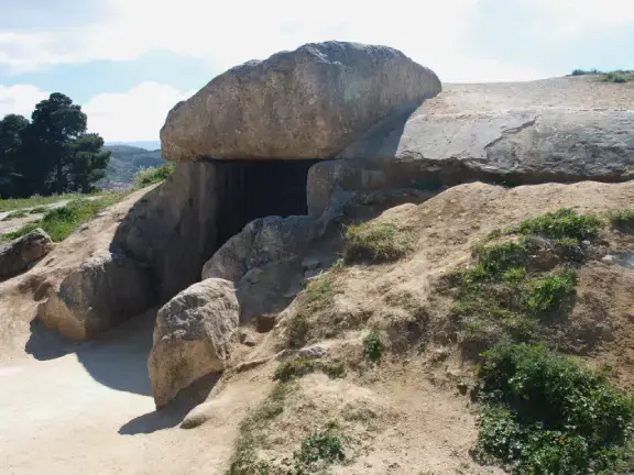
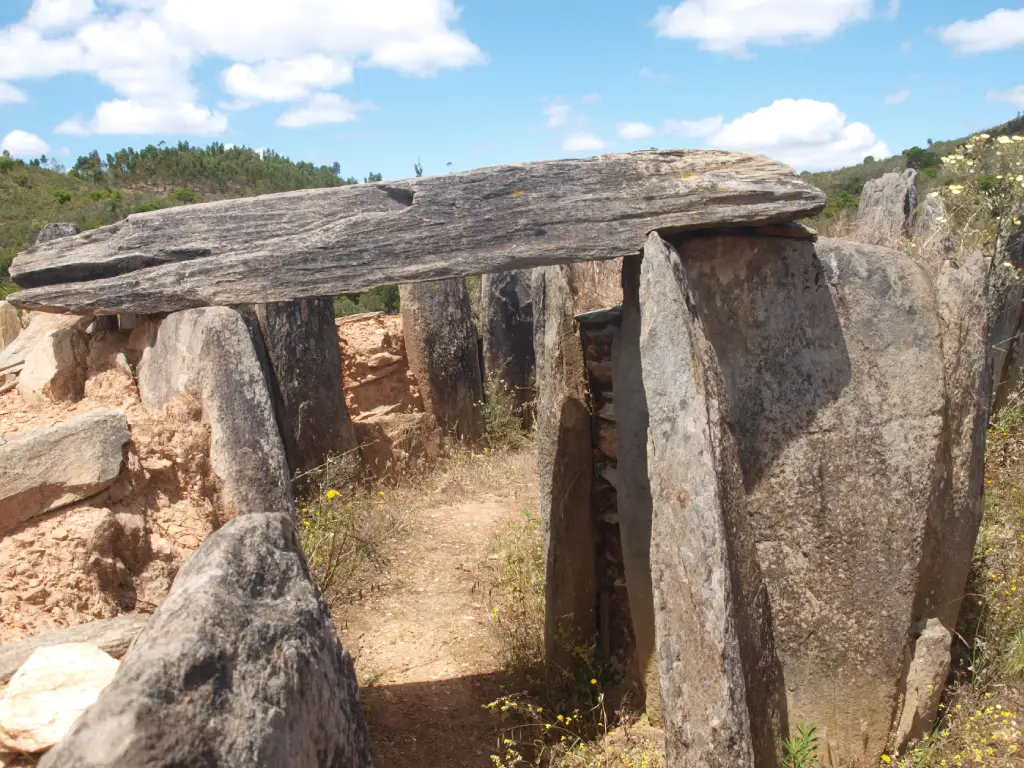
The Architecture of Anxiety: Megaliths of Southwestern Iberia - Dolmen 3 at Pozuelo
Dolmen 3 at Pozuelo

The Expanding Horizon and the Anxiety of Exchange

As we trace the megalithic phenomenon south into Extremadura and Andalucia, the foundational driver of the "Architecture of Anxiety", the need to define and hold territory, remains constant. The arid climax of the Holocene Optimum affected the entire southwestern peninsula, and indigenous communities continued to use the bones of their ancestors to lay claim to vital resources. In the fertile valleys of the south, this climatic anxiety began to intertwine with the way in which communities conducted exchange.

The Neolithic spread into southern Iberia took barely 500 years. It was not an overland slog, but a maritime phenomenon [Zilhão, 2001]. Early farming communities expanded from northeastern Spain down the Mediterranean coast, rounding the peninsula into Cadiz and Huelva provinces and thence up the Portuguese coast to Galicia. This was achieved through "coastal hopping", short voyages defined by how far a crew could paddle in a day before pulling their vessels onto a sheltered beach.

Because of this, the coastal populations of the south were intimately familiar with the sea and the maritime routes adjacent to their home territories. Once established, these pioneers populated major river valleys, such as the Ebro, Segura, Guadalquivir, Guadiana, and the Tagus, from the sea, moving upriver. Lacking advanced ploughs, they initially claimed the lighter, easily worked soils of the higher river terraces and tributaries. Only later, as populations expanded and this prime real estate ran out, were subsequent generations forced down into the heavier, waterlogged clays of the lower river sections and valley floors.

In the river valleys the Neolithic newcomers encountered a thinly spread indigenous Mesolithic population. Rather than being violently displaced, evidence suggests these hunter-gatherers were gradually assimilated into the new agricultural way of life. After this rapid initial spread, there is little evidence of continuous waves of seafaring reinforcements. The communities that emerged were a relatively static, fused population that expanded organically within their chosen territories.

As communities transitioned from a semi-nomadic lifestyle to permanent, open-air agricultural villages in the Middle to Late Neolithic, they shifted their preference toward elevated fluvial terraces right above the active floodplains (Carmona 2011). As mentioned, early Neolithic pioneers often avoided the wide, swampy, and unpredictable main channels of the largest rivers (like the lower Ebro). Instead, they preferred narrower tributary valleys and secondary river corridors. The secondary streams were much easier to manage, safer to cross, and served as navigable "highways" leading from the Mediterranean coast straight into the mountainous interior.

Inland, the landscape was already crisscrossed by terrestrial paths used by the indigenous hunter-gatherers. However, their traditional meeting places, often situated at prominent river bends or sheltered coastal inlets, were driven by biological necessity rather than economics. Small, highly mobile bands gathered at these nodes seasonally to exchange mates, a vital practice to prevent inbreeding [Cabello-Ligero et al., 2025].

As the agro-pastoral lifestyle took hold, the function of these ancient gathering spots fundamentally changed. Footpaths were widened by the hooves of newly introduced herds of sheep, goats, and cattle, becoming established drovers' routes. The seasonal biological gatherings evolved into recognised trading places. These were not markets or ports in any modern sense, but traditional meeting places where now-settled farming clans swapped surplus livestock, flint, and pottery.

The anxiety that manifests in the megaliths of the southwestern part of the Iberian Peninsula is intrinsically linked to these places of exchange. Through this slow, coastal-hopping network and the developing drovers' routes, rare and exotic items, amber, ivory, and eventually early metals, began to trickle into the local communities. The arrival of these high-status goods disrupted the egalitarian balance of the farming clans. It created a new kind of social pressure: the anxiety of prestige and unequal wealth.

Megalithic dolmens were not built to guard physical borders; the fortified walls of settlements like Los Millares would come much later. Instead, the early dolmens were psychological anchors. As the landscape became busier and the informal trade networks became lucrative, local lineages needed an undeniable way to assert their identity. By building increasingly massive ancestral tombs near sheltered beaches, river bends, and drovers' paths, communities embedded their lineage into the landscape, claiming their traditional right to participate in the exchange.

Yet, this psychological attempt to maintain the status quo ultimately failed. The trickle of exotic wealth forged a society of extreme inequality, giving rise to ritual elites and sparking architectural achievements that force a re-evaluation of these early farming communities.

Bridging the Borderless Plains: Lácara and the Twin

To understand how this anxiety manifested, we must discard modern political maps. In the 4th millennium BCE, the border between Portugal and Spain did not exist. The baked plains of the Alentejo roll seamlessly eastwards into Extremadura. This was not a pre-packaged landscape waiting to be exploited. Early agro-pastoralists were actively engineering it. By clearing dense underbrush for grazing while selectively conserving stands of oak to provide themselves with fuel and fodder for their pigs, these communities were forging the proto-dehesa, a managed, open woodland ecosystem. To this day, the Spanish have a nostalgic love of their dehesa, few realise the roots of that nostalgia go back six thousand years.

Extremadura was not an empty frontier awaiting climate refugees. Indigenous farming communities already populated it. The "Architecture of Anxiety" spread south and eastward not because of a mass human exodus, but because the climate collapse did not respect borders. The established populations of Extremadura were experiencing the exact same ecological degradation as their neighbours in the Alentejo, and they adopted the identical architectural solution to lock down their shrinking resources and traditional drovers' routes.

Dolmen del Mellizo (The Twin)

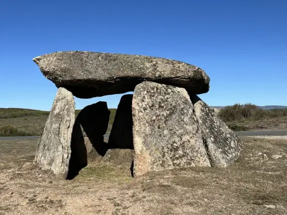
This shared architectural reflex is stamped across the Extremaduran landscape. Situated roughly 100 kilometres northwest of Mérida, right on the modern Portuguese border in Valencia de Alcántara, sits the Dolmen del Mellizo (The Twin). It is one of over forty megalithic tombs clustered in that specific area. The sheer density of dolmens in this borderland reinforces the thesis. As the climate degraded and social pressures mounted, the need to permanently mark territory became a necessity among local clans.

Dolmen de Lácara

Further southeast, the Dolmen de Lácara acts as the ultimate architectural bridge connecting these inland plains to the Andalucian south. Constructed between 4000 and 3000 BCE, Lácara is a massive passage grave that structurally and conceptually rivals the large antas of Portugal. Featuring a corridor that originally stretched some twenty metres to a polygonal chamber, it was once buried beneath an enormous earthen mound.

Together, Mellizo and Lácara are titanic territorial statements. They prove that the communities of Extremadura were anchoring themselves to their own landscape. Facing the same severe climatic stress as their western neighbours, they were locking down their local resources, pastures, and drovers' routes. By building these colossal monuments, they ensured their lineages remained rooted and resilient in their own territories, even as a wider, peninsula-spanning network of prestige exchange began to slowly emerge around them. When the dolmens were built, society was based on collective clans, and the right to the land was held by the ancestors. But by the Late Bronze Age (c. 1200 BCE), when true bronze became the ultimate source of wealth and military power, society shifted drastically toward individual warrior elites. The old egalitarian clan structure was dead.

The Sierra Morena Ore Routes: The Chronology of Pozuelo

As we move south from Extremadura, the landscape and resources change. Roughly 200 kilometres south of Lácara, on the southern flanks of the Sierra Morena, lies the megalithic complex of El Pozuelo (Zalamea la Real, Huelva).

This site sits in a heavily wooded area of steep slopes, ravines, and streams. The dolmens here, primarily passage graves, are situated at the ends of short ridges. They were not designed to be visible from vast distances, nor do they yield the exotic trade goods found in other dolmens. The detailed chronology of the Los Llanetes group within this complex maps the escalating "Architecture of Anxiety" over two thousand years [Linares-Catela, 2022].

Around 4000 BCE, anxiety was low. The site was an open-air sacred space on a terraced promontory. Several free-standing stelae were erected, aligned towards the winter solstice. It was a place of seasonal, biological gathering.

However, by 3500 – 3250 BCE, as the Neolithic population increased and the climate began to dry, the need to establish permanent ownership of the land intensified. The first megalith (Dolmen 4) was constructed. The builders deliberately fractured the bases of the ancient, free-standing stelae and reused them to support the massive capstones of the new chamber, alongside an anthropomorphic stela carved with round eyes. They physically fused the ancient sacred past into a permanent claim of territorial ownership.

By 3000 BCE, the anxiety of exchange was taking hold across the region. Copper was beginning to be noticed, and the Rio Tinto mines nearby were active. In response, the Pozuelo builders cemented their claim through monumental expansion. Rather than building defensive walls, they expanded their sacred footprint, creating perimeter terraces to enhance ceremonial staging. They constructed the unusual Dolmen 3, featuring a single passage diverging into two spacious chambers. This unique layout illustrates that the builders were not following a unified blueprint imported from the coast. Instead, they engineered an idiosyncratic, local architectural solution to address their own specific social needs.

Simultaneously, they renovated Dolmen 4, adding stone paving and external altars. The architecture expanded not to act as a military stronghold, but to accommodate a larger, elaborate ritual focus, loudly projecting their deep ancestral permanence.

This collective clan anxiety held the territory until roughly 2000 BCE, when early metallurgy disrupted the egalitarian society. Burial practices at Pozuelo shifted abruptly to individual cist graves (such as in Dolmen 6), demonstrating a new focus on the rank and standing of the deceased.

Finally, the collective "Architecture of Anxiety" collapsed entirely. Between 1200 and 700 BCE, true bronze production exploded. The Chinflón mine, about 600 metres from the Los Llanetes group, were heavily exploited. During this period of industrialised mining, Dolmens 3 and 4 were deliberately destroyed. Mining hammers have been found scattered among the broken orthostats and removed capstones. This was not random vandalism. It was the deliberate erasure of collective land rights by a new, individualistic elite. The ancestors no longer held the deed to the hills; the masters of the bronze did.

While Pozuelo demonstrates this anxiety on a micro, localized scale, we only have to travel 40 kilometres south to the Dolmen de Soto to see it on a macro scale. Situated on the northern side of the Rio Tinto, a major ore transit route to the Huelva estuaries, Soto required the collective labour of hundreds of people. It was not an exchange node, it was a statement of dominance over the transit route itself.

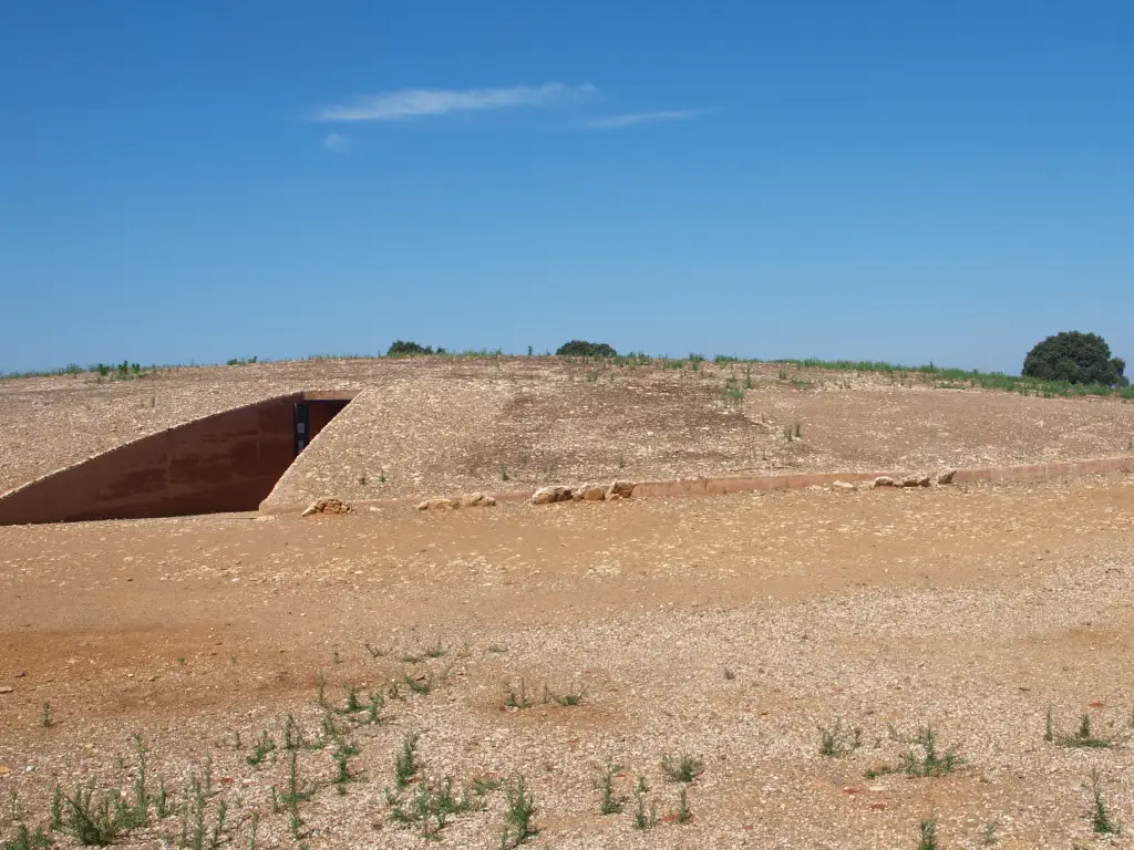
The Architecture of Anxiety: Megaliths of Southwestern Iberia - Dolmen Soto Trigueros
Dolmen Soto Trigueros

The Route to the Coast: Dolmen de Soto and the Rise of the Tribe

If the scattered dolmens of Pozuelo represent individual families marking local plots, the Dolmen de Soto represents something entirely different. Located roughly 40 kilometres south of Pozuelo in the municipality of Trigueros (Huelva), it sits on the northern side of the Rio Tinto.

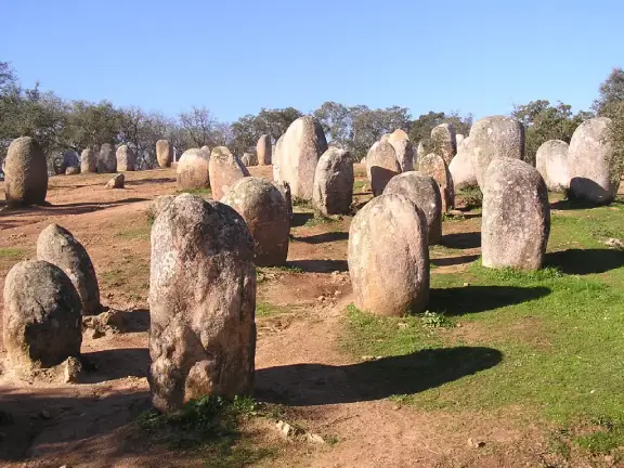
Soto is a massive monument, but its significance lies in what it destroyed. Sometime before 3000 BCE (possibly as early as 3800 BCE), in response to the early climatic pressures of the Holocene Arid Climax, the local Neolithic population erected a stone circle on this site. Measuring 65 metres in diameter and utilising at least 94 pillars painted a striking red, it was a bold territorial marker, yet it remained an open, communal structure. Some stones, weighing up to 21 tons, were dragged from quarries 30 kilometres away. This circle represented the last gasp of the egalitarian society, an open, visible gathering place for seasonal observation or broad exchange.

Between 3000 and 2500 BCE, a secondary, far more destructive pressure took hold: the anxiety of prestige. As exotic wealth from the coast began to funnel up the Rio Tinto transit route, the egalitarian clan structure collapsed. The newly formed, wealth-hoarding tribal elite deliberately dismantled the open circle. The massive stones were repurposed to construct a dark, enclosed corridor tomb extending 21.5 metres in length. The corridor was lined with 63 orthostats and roofed with 30 capstones, buried beneath an earthen tumulus 60 metres in diameter and 3.5 metres high.

Despite its scale, the tumulus was not designed to dominate the skyline. It was engineered to blend into the rolling topography of the river basin. These builders were naturalising their dominance. By replacing a highly visible, open-air stone circle with a subterranean tomb disguised as a natural hill, the newly formed tribal elite were making a statement: their ancestral claim to the Rio Tinto corridor was now as permanent as the geology itself. They did not need a stela on top because the hill itself was the monument.

This unassuming exterior amplified the psychological shock of the interior. Imagine being a stranger permitted to approach this "natural" hill, only to be led into a dark, narrow corridor lined with massive stones.

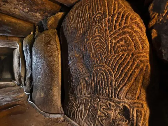
Inside, the builders weaponised the space. Research utilising new lighting techniques revealed an astonishing array of previously hidden engravings [Bueno-Ramírez et al., 2021]. The orthostats are covered in armed figures, daggers, and V-shaped motifs. As Bueno-Ramírez noted, “There is not a single megalithic monument in Europe with so many armed figures on its walls”. The transition from a quiet rolling landscape to a dark, weapon-carved subterranean chamber was a visible reminder of who controlled the valley.

Amidst this martial display, human remains recovered during Hugo Obermaier’s original 1922 excavations provide another piece of the puzzle. Beneath an engraved stone, archaeologists found the remains of a woman and a child, accompanied by a curated collection of grave goods, polished axe heads, flint knives, hand-made pottery, and a conical bone bracelet.

The burial included marine seashells and beads. In the context of this expanding demographic funnel, these artifacts represent undeniable physical evidence of an inland community engaged in a prestige economy with coastal maritime networks.

Dolmen de Soto was built when scattered family groups of the Guadalquivir and Rio Tinto basins were forced by demographic pressure and the influx of coastal trade to coalesce into larger, unified "tribes." The logistics of building Soto, requiring hundreds of workers and a dedicated supply chain of food, proves a new level of social hierarchy had emerged to command mass labour.

By burying their dead here with imported marine goods, erasing the old public gathering space, and covering the walls with weapons, this newly unified tribe was delivering a message. They were warning anyone moving raw ores downriver or carrying coastal prestige goods upriver, "We are the land, we control this route, we have the numbers to defend it, and we reap the rewards of the exchange."

The Grand Trading Place: Valencina de la Concepción

If Dolmen de Soto represented tribal control of a transit route, Valencina de la Concepción was the destination. Situated just west of modern Seville, it sits on a ridge that, 5,000 years ago, overlooked a large bay connecting the Guadalquivir river to the Atlantic Ocean.

This was the ultimate ecotone. It offered marine resources from the saltwater estuary, fresh water from the Guadalquivir, and fertile land for the cultivation of crops and the raising of domesticated pigs and goats. Between 3000 BCE and 1500 BCE, this location blossomed into a sprawling mega-site, covering between 300 and 400 hectares. It was the Grand Trading Place, the point where coastal-hopping maritime networks met inland drovers' routes.

Initially, evidence suggests an egalitarian society. The site lacks the defensive stone walls seen at later Copper Age settlements like Los Millares. The early inhabitants lived in round, mud-walled huts and dug massive ditches. But as populations from across the southwestern peninsula funnelled into this massive gathering place to trade surplus livestock, flint, and pottery, the social friction, the anxiety of the collective, would have been immense.

How did a visiting herder from the Pozuelo clan or a trader from the Soto tribe prove their right to participate in this bustling market? The answer lies in one of the most enigmatic artifacts of the Iberian Chalcolithic, the slate plaque idol.

Found in funerary contexts from Portugal to eastern Andalucia, these palm-sized, highly decorated schist plaques feature complex geometric patterns. Within the "Architecture of Anxiety" framework, these plaques functioned as portable territorial markers. The specific geometric engravings acted as lineage codes, the Chalcolithic equivalent of a clan tartan or a passport. When navigating a tense, multi-community centre like Valencina, the plaque idol proved tribal identity and ancestral right to be there.

To enforce this system in an environment where strangers mixed and extreme wealth flowed, trust broke down, necessitating psychological policing. Many of these plaque idols, alongside separate cylindrical stone betyls found across the region, share a distinct feature, deeply incised, staring "owl eyes". As nocturnal predators, owls see what is hidden in the dark. If the geometric patterns on the plaque represented the lineage code, the owl eyes acted as a divine seal of authority, projecting the surveillance of the "watchful ancestor." They served as a reminder that every exchange and interaction was monitored by the unsleeping dead and the ritual elite who communed with them.

Ultimately this egalitarian system of communal ranking could not survive the wealth flowing into the estuary. Valencina became a hot bed for extreme social inequality, driven by the arrival of foreign, high-status goods.

The Rise of the Ritual Elite

As centuries progressed, the architecture at Valencina shifted from communal ditches to monumental, elite tholoi (false-dome tombs). The concentration of exotic wealth found within these structures confirms that an authoritarian, hierarchical society had taken control during the peak period of the site, between roughly 2900 and 2650 BCE.

The most revealing evidence comes from Structure 10042/10049. In the lower level of this two-chambered tomb, archaeologists found a single inhumation drenched in red cinnabar pigment, surrounded by unimaginable wealth: an entire elephant tusk, a flint halberd with an amber pommel, and numerous ivory objects. The upper level contained an ostrich egg and a masterpiece rock crystal dagger.

For years, this individual was assumed to be a male warrior-king. However, in 2023, peptide analysis of the tooth enamel proved that this was the "Ivory Lady", who lived and died between 2900 and 2800 BCE [Cintas-Peña et al., 2023]. She is the highest-status individual discovered to date in all of Copper Age Iberia. She was not buried with gold or massed weaponry; she was buried with esoteric, magical items (amber, rock crystal, cinnabar, African ivory). This suggests the elite who seized control of Valencina did not rely solely on physical coercion, but on religious and ritual fear.

The discovery of the Ivory Lady disrupts traditional assumptions about Copper Age power dynamics. We should be careful not to hastily label Valencina a "matriarchy", a system where women inherently ruled over men. Instead, the evidence points to a society where biological sex was secondary to ritual supremacy. In a world increasingly driven by the anxiety of exchange, absolute power did not rest with the strongest warrior. It rested with those who controlled the esoteric knowledge, the ancestral lineages, and the exotic prestige goods flowing in from the coast. In many ways, we are looking at the Copper Age Andalucian equivalent of an ancient Greek Oracle. The Ivory Lady ruled not by the sword, but through the psychological, religious, and economic authority she commanded from her estuarine metropolis.

This is corroborated by the colossal Montelirio tholos, a 43.75-metre-long construction built roughly two to three generations after the Ivory Lady (c. 2875–2700 BCE). The main chamber contained 20 individuals, clad in spectacular shrouds made from tens of thousands of perforated beads. Recent osteological analysis reveals these individuals were predominantly women, many suffering from physical deformities associated with repetitive craftwork and severe mercury poisoning from handling cinnabar [Fontanals-Coll et al., 2015]. They appear to have been a subservient caste of priestesses or artisans, literally worked to death and sacrificed to accompany the elite.

This consolidation of power eventually required physical enforcement. Near the La Pastora tholos, a later monument built between 2650 and 2400 BCE, archaeologists recovered a hoard of 29 exceptionally long copper javelin points. For decades, their unusual design sparked controversy, with some scholars arguing they were imports from the Eastern Mediterranean. However, recent lead isotope analyses have proven they were manufactured entirely from Iberian copper sourced from multiple geological deposits across the southwest, including the Sierra Morena (Hunt Ortiz et al., 2012). This proves that Valencina actively drew resources from all the inland drovers' routes. Javelins are specialised weapons for killing. As the wealth of Valencina reached its zenith, esoteric ritual prestige was no longer enough. The "Architecture of Anxiety" reached a violent climax: the elite hoarded weapons to defend their monopoly.

The architecture of these elite tombs reflects this consolidation of power. La Pastora features a massive 43.1-metre corridor, the longest in the Iberian Peninsula, terminating in a mud-brick tholos dome. Uniquely, it faces west, toward the sunset, breaking the traditional solar alignments of older, egalitarian dolmens.

The Matarrubilla passage grave contains a massive carved marble block serving as an altar. Recent geological studies prove this multi-ton stone was quarried on the opposite side of the Guadalquivir estuary, meaning the elite commanded the maritime logistics and the labour force necessary to raft it across the river and drag it to the tomb.

Valencina represents the climax of the anxiety of exchange. The wealth of the Mediterranean and inland drovers' routes created a sprawling metropolis, but the price of that prestige was the total destruction of the egalitarian Neolithic world, replaced by an authoritarian society ruled by ritual elites wielding unimaginable, esoteric power. Yet, this power was fragile. Recent extensive radiocarbon dating reveals that Valencina did not slowly fade into the Bronze Age; it suffered a catastrophic collapse around 2300 BCE. As true bronze and silver birthed a new, highly martial era of individual warrior elites across Iberia, the ritual power of the Ivory Lady and the coastal trade networks became obsolete. The massive estuarine trading centre was abandoned, leaving the watchful ancestors alone in the dark.

References and Further Reading

  • Bueno-Ramírez, P., Balbín-Behrmann, R., et al. (2021). Studies and interpretations of armed figures in Iberian megalithic art, specifically detailing the martial engravings inside the Dolmen de Soto.
  • Cabello-Ligero, L., Bueno-Ramírez, P., et al. (2025). The Menhir as an Oral Tradition in Cattle-Raising Territories. MDPI. (Details the role of megaliths and meeting places along ancient prehistoric drovers' routes).
  • Carmona, Pilar & Ballester, José. (2011). Geomorphology, geoarchaeology and ancient settlement in the Valencian Gulf (Spain). Méditerranée. 117. 61-72. 10.4000/mediterranee.5920.
  • Cintas-Peña, M., García Sanjuán, L., et al. (2023). Amelogenin peptide analyses reveal female leadership in Copper Age Iberia (c. 2900–2650 BC). Scientific Reports. (The landmark peptide study identifying the "Ivory Lady" at Valencina de la Concepción).
  • Fontanals-Coll, M., et al. (2015/2020). Anthropological, osteological, and isotopic studies of the human remains at the Montelirio tholos, detailing the demographics, craft-based deformities, and mercury exposure of the interned women.
  • Hunt Ortiz, M. A., Montero Ruiz, I., et al. (2012). Compositional and lead isotope analysis of the La Pastora javelins, confirming their Iberian provenance and varied geological sources.
  • Linares-Catela, J. A. (2022). Radiocarbon Chronology of Dolmens in the Iberian Southwest: Architectural Sequence and Temporality in the El Pozuelo Megalithic Complex. Radiocarbon. (Definitive sequencing of the multi-phase expansions at the Pozuelo site).
  • Zilhão, J. (2001). Radiocarbon evidence for maritime pioneer colonization at the origins of farming in west Mediterranean Europe. PNAS. (Contextualizing the rapid, short-hop maritime spread of the Neolithic).
Legacy Reloaded: A dev, an AI, and the relentless pursuit of 100

Enjoying this clean, uncluttered read?

You are currently browsing the result of a massive technical overhaul. My new book, Legacy Reloaded: A dev, an AI, and the relentless pursuit of 100, chronicles the journey of transforming an aging legacy website into a modern, lightning-fast platform that hits the perfect 90+, 100, 100, 100, 3/3 Lighthouse metrics. It’s a story of collaboration between developer and AI, and the stubborn pursuit of technical perfection.

Read the Story

You have finished reading chapter 5

More articles in the The Megalithic Phenomenon and the Architecture of Anxiety series: