Ancient Mediterranean Shipyards and Harbours
Wadi al-Jarf: Egyptian Expeditions to the Copper Mines of Sinai 2600 – 2566 BC
Wadi el-Jarf, the world's oldest known artificial harbour, was briefly used during the late Fourth Dynasty (c. 2600 BC) under King Khufu. Its function was to launch expeditions to the Sinai Peninsula's mines. The site's rock-cut galleries and a cache of papyri, known as the Diaries of Merer, provide direct evidence of the logistics for these state-sponsored missions.
By Nick Nutter on 2025-09-1 | Last Updated 2026-01-17 | Ancient Mediterranean Shipyards and Harbours
This article has been visited 4,016 times

Wadi al-Jarf. Photo G. Marouard
Wadi al-Jarf Breakwater: Early Egyptian Maritime Engineering
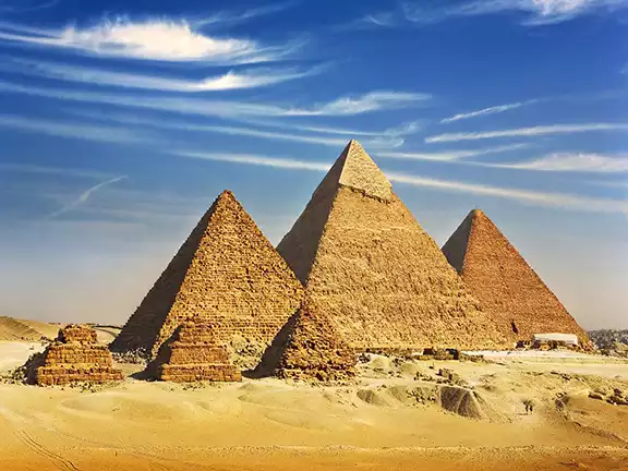
During the reign of Khufu and his son, Khafre, between 2600 and 2500 BC, the Egyptian state embarked on a massive building programme, the Giza Necropolis. The site includes the Great Pyramid of Khufu, the Pyramid of Khafre, and the Pyramid of Menkaure, along with the Great Sphinx, smaller "queens'" pyramids, temples, causeways, and cemeteries.
All the materials to build these monuments had to be brought on to the Giza Plateaux from distant sources, limestone from Tura, south of modern Cairo, granite from Aswan, and copper, from the Sinai. The materials were assembled at Ro-She Khufu, a purpose-built harbour, cut out of the sand and rock beneath the plateaux, before being moved to the various construction sites on the plateaux itself.
Excavations at four significant sites, Wadi al-Jarf, El-Markha, Wadi Maghara, and Wadi al-Nasb, have enabled researchers to reconstruct the logistical framework of early state-sponsored expeditions from Egypt to the Sinai Peninsula. These journeys sought copper, essential for the production of tools and weaponry, as well as turquoise, an opaque greenish-blue gemstone that held substantial value throughout Egypt’s history. Wadi al-Jarf was a purpose-built facility, operational for approximately fifty years.
Wadi al-Jarf the world's oldest known artificial harbour
The Wadi al-Jarf breakwater is a relatively recent archaeological discovery on Egypt's Red Sea coast.
A French Egyptian archaeological team led by Pierre Tallet began excavating the Wadi al-Jarf site in 2011. While the site itself, including the cave galleries, had been noted by others as far back as the 19th century, it was Tallet's team that systematically excavated the area and identified the breakwater and other structures as the components of the world's oldest known artificial harbour.
Strategic Location of Wadi al-Jarf
The Wadi al-Jarf breakwater is situated on the Red Sea coast of Egypt, about 119 km south of Suez, at the mouth of the Wadi Araba. The site provided the most direct maritime route to Sinai but necessitated a challenging 160-kilometre journey across the desert from the Nile Valley for resupply.
Building Wadi al-Jarf
Archaeologists identified the site of Wadi al-Jarf as a harbour complex dating back to the reign of Pharaoh Khufu, who reigned between 2589 and 2566 BC. Pharaoh Khufu (also known as Cheops) was the pharaoh responsible for the Great Pyramid of Giza, though some evidence suggests earlier use under Khufu’s predecessor, Snefru, the founder of the 4th Dynasty who reigned between 2613 and 2589 BC.
The Excavations at Wadi al-Jarf
The excavation revealed a range of features, including a series of 25 to 30 storage galleries carved into the limestone hills, boat fragments, and, most crucially, a now submerged jetty or breakwater. Today, only part of it is visible on a rocky headland. It extends eastward for about 160 metres, then irregularly south for about 130 metres.Over four and a half thousand years ago, workers constructed an L-shaped structure from large limestone blocks and pebbles. The finished breakwater was approximately 325 metres long and extended into the water to create a protected basin covering about 5.67 hectares. The basin was large enough to shelter a fleet of large transport ships from the persistent northern waves and currents. Over 4 millennia ago, the Egyptians were demonstrating a remarkable mastery of marine engineering and project management.
In April 2024, the French Institute of Oriental Archaeology (IFAO) released the first comprehensive volume on the coastal sector of the site, titled Ouadi el-Jarf I: Les installations du littoral. Authored by Pierre Tallet, Grégory Marouard, and Damien Laisney, this volume consolidates the results of excavations conducted between 2012 and 2021.
Carved into the mountains about 6 kilometres west of the seashore, archaeologists discovered a system of storage galleries, each 16 to 34 metres long, 3 metres wide, and 2.5 metres tall. The Egyptians used these to store deck hardware, rigging and boat kits, shipping materials, and supplies for voyages. Study of the locally produced storage jars, which were often used for water, confirm these were part of the cargo for sailing expeditions.
Nearby was a workers village for the sailors, crews and dockyard labourers.
Over 100 limestone anchors have been excavated from the site. Some had been re-used in building structures, most were found in the positions in which they had been originally placed, ready for future use. Some of the anchors bore hieroglyphs that are thought to represent the names of individual transport ships.
Do you enjoy my articles? For your reading pleasure, this website does not carry third party ads. You could help me write more articles by buying me a cup of coffee.
The Red Sea Scrolls


Excavated Gallery at Wadi al-Jarf
In 2013, archaeologists discovered a cache of papyri fragments. They have been dubbed ‘The Red Sea Scrolls’ and it is from these that we can deduce some of the details of the expeditions that departed and returned to Wadi al-Jarf and invaluable insights into the daily lives and organization of the Old Kingdom. Ironically, one of the fragments, the ‘Diary of Merer’, was probably left at Wadi al-Jarf by mistake.
Merer had the rank of Inspector within the Egyptian workforce. His ‘diary’ is actually a logbook covering 28 days’ worth of work, quarrying and transporting limestone from Tura, on the River Nile, to the Giza Plateaux, the scene of massive building works, including the Great Pyramid, during this period. Whilst the logistics revealed in the diary are not pertinent to this article, some of the detail is. For instance, the Egyptians had a 10-day working week (decans). The civil calendar included five epagomenal days at the end of the year to align the 36 working weeks with the solar year.
An Expedition to the Sinai between 2600 and 2500 BC
From all the information garnered from the archaeological sites, we can reconstruct an expedition to the Sinai Peninsula as it would have been between 2600 and 2500 BC. The expeditions started at Wadi al-Jarf.
Departing Wadi al-Jarf
Before leaving Wadi al-Jarf, the transport boats had to be assembled. Primarily built to sail on the River Nile, the ships were constructed in such a way that they could be disassembled, carried from the Nile to Wadi al-Jarf and stored in the caverns near the port. These expeditions were not small-scale affairs, each one likely consisted of 1000 men, or more. Based on the size of the galleries and the wooden parts recovered, we can estimate the size and carrying capacity of each boat.
They were approximately 25 to 30 metres in length, with a beam of 6 to 8 metres. Whilst the principle means of propulsion was a square sail, each ship also carried 20 to 30 rowers. The total crew size would have been 40 to 50 men, with, on an outward journey, up to 50 ‘passengers’ who would be tasked with mining, quarrying and smelting at sites on the Sinai Peninsula.
Unlike modern ships held together with nails, the planks were joined using mortise-and-tenon joints and then lashed tightly together with ropes. This allowed the boat to "flex" in the rougher Red Sea waters and allowed them to be dismantled for storage.
Each ship was capable of carrying between 40 and 60 tons of cargo. On the outward voyage, much of this would have been water since there is no source of potable water at the mining sites on Sinai.
Each expedition probably consisted of a fleet of 10 or more ships.
Their destination was the fortress at Tell Ras Budran.
El-Markha (Tell Ras Budran)
The ships launching from Wadi al-Jarf headed to a specific "bridgehead" on the Sinai coast, the fortress of El-Markha. El-Markha was some 45 to 50 kilometres away, directly across the Gulf of Suez from Wadi al-Jarf. The Egyptian ships of the time, although designed primarily for sailing on a river, would probably have made the crossing in a single day.
From El-Markha, donkey caravans, escorted by the stone masons, miners, scribes and smelting specialists brought over on the ships, carried supplies 30 to 50 kilometres north to Wadi Maghara and later, towards the end of the 26th century BC, a further 10 kilometres north into the mountains to Serabit el-Khadim.
---------------------------
Fun Fact - The Unsung Heroes: The Sinai expeditions ran on donkey power. A single expedition could require a train of over 500 donkeys. These animals were the logistical lifeline, carrying not just the copper ore back to the coast, but, crucially, carrying water from the coast to the waterless mines. There is an ancient logistical rule of thumb, for every donkey carrying copper ore, two or three were needed just to haul the water and grain to keep the team alive.
---------------------------
Wadi Maghara
Wadi Maghara was the primary source for copper and turquoise during the Old Kingdom. It is famous for its rock-cut reliefs of pharaohs (including Khufu and Sneferu) "smiting the enemy," symbolizing the king's control over this chaotic desert frontier.
Geographically, the active mining zone at Wadi Maghara is surprisingly compact compared to the massive scale of the expeditions.
The actual mines are concentrated along the steep cliffs of a side valley, Wadi Igneh, that branches off the main wadi. The primary galleries are located roughly 50 to 75 metres up the cliff face. The main area of activity extends for only about 400 to 500 metres along the wadi walls.
The ancient Egyptians called this site Khetyou Mefkat, or "The Terraces of Turquoise." This likely refers to the geological strata where the turquoise nodules were found, horizontal bands in the sandstone cliffs that required miners to cut "galleries" to follow the veins.
A workers camp was located on the summit of a small, steep-sided hill in Wadi Igneh, directly opposite the mining galleries. This elevated position was chosen for security, creating a natural fortress.
Excavations revealed approximately 125 rough stone huts. These were dry-stone structures originally roofed with perishable materials like branches or mats. The huts are small and packed closely together, suggesting a crowded living environment for the lower-class labourers, the stone masons and miners.
The settlement was heavily fortified. A long stone wall ran along the perimeter to protect the workers from local tribal raids, and the only access to the summit was via a fortified stone staircase.
Inside the camp, archaeologists found deep layers of wood ash from cooking fires, Old Kingdom pottery, and copper chisels, confirming it was the living quarters for the workforce.
Distinct from the rough workers' huts, there is evidence of a hierarchy on the site.
At the foot of the hill (or slightly separated from the main worker cluster), there are remains of better-constructed stone buildings with smoothed walls. These are believed to be the administrative headquarters for the expedition leaders and storage for the valuable turquoise and copper.
While most of the smelting happened at Wadi al-Nasb, evidence of copper processing (slag, crucibles, and crushed ore) has also been found near these administrative buildings at Wadi Maghara, indicating some on-site processing, possibly manufacturing and repairing tools for use at the site.
During the Middle Kingdom, Wadi Maghara lost its primacy as a source of copper. Attention then focused on Serabit el-Khadim. While they still mined copper and turquoise at Wadi Maghara, inscriptions there prove Middle Kingdom kings like Amenemhat III sent teams, the vast majority of resources and manpower were directed to the growing temple complex at Serabit el-Khadim.
From Wadi Maghara, donkey caravans
Wadi al-Nasb
Wadi Maghara was the extraction site and Wadi al-Nasb was the "factory" where raw ore was turned into transportable metal. It contains the largest ancient slag heap in the entire Sinai Peninsula, waste that had accumulated over thousands of years from its inception about 2600 BC until well into the New Kingdom period.
In fact, the site is dominated by this black mound of copper slag, the stony waste separated from metal, estimated to weigh roughly 100,000 tons. This heap covers an area roughly 300 metres by 200 metres and stands 2 to 3 metres high. Modern archaeometallurgists estimate this waste pile represents the production of approximately 5,000 to 5,500 tons of pure copper over the site's history, an immense amount of wealth for the ancient world.
The smelting operation was highly organized, resembling a modern production line rather than a cottage industry.
Excavations (including recent work by Pierre Tallet) identified long rows of furnaces arranged in "batteries." At the specific locality of Seh Nasb, just one part of the complex, archaeologists found traces of 27 distinct batteries containing over 3,000 individual smelting units.
During the Old Kingdom, the Egyptians ingeniously placed these furnace batteries on wind-swept ridges. They utilised natural wind power to create a "chimney effect", to drive air into the fires, reaching the ~1,200°C needed to melt copper without exhausting the workers with constant blowing.
The industrial zone was supported by a fortified settlement that was centred on Bir Nasib, a reliable water well (Bir means well), which is still used today. This water source made it the natural headquarters for processing ore from the waterless mines at Wadi Maghara.
Donkey caravans arrived at Wadi al-Nasb carrying the copper ore from the mines at Wadi Maghara. Workers crushed the rock into gravel-sized pellets using handheld stone pounders, of which thousands have been found at the site. The crushed ore was mixed with charcoal, made from local acacia trees, and flux, then fired in the furnace batteries.
Flux was the critical chemical catalyst that transformed copper smelting from a small-scale experiment into a massive industry. Its importance lies in its ability to solve the primary chemical problem of smelting, silica. Copper ore is naturally embedded in quartz (silica) rock, which has an incredibly high melting point—higher than the copper itself. Without flux, the silica would remain a sticky, viscous mass inside the furnace, trapping the molten copper and preventing it from pooling together. To solve this, the Egyptians added crushed iron oxide (hematite) as a flux.
-------------------------------
Fun Fact: The need for flux was actually discovered in the Balkans about 5000 BC where the Vinca people used manganese rich ores as a flux.
-------------------------------
The iron in the flux reacted chemically with the silica in the ore to create a new compound called iron silicate (slag). This slag melted at a much lower temperature, turning into a liquid that easily separated from the heavier molten copper. This allowed the copper to sink to the bottom of the furnace while the waste slag could be tapped off or broken away, enabling the high-volume production seen in the 100,000 ton waste heaps.
-------------------------------
Fun Fact: Many scholars consider this accidental production of iron to be the catalyst that ushered in the Iron Age.
------------------------------
The resulting small droplets of copper, called "prills", were separated from the slag and melted down again in crucibles to be cast into ingots, standardized shapes that could be easily loaded onto donkeys and walked back to the ships at the Red Sea coast.
Wadi al-Nasb was a place where Egyptians and "Asiatics" (Canaanites) mixed. The site contains inscriptions in the Proto-Sinaitic script (the earliest alphabet), confirming that the Semitic labourers who invented the alphabet were also the workforce powering these massive smelters.
Supplying the Royal Workshops
The copper ingots were loaded onto the long-suffering donkeys and walked back to the fortress of El-Markha. Scribes recorded the quantities of copper ore extracted and pure copper produced at each stage of the journey, from mine to smelters to Egypt.
Back at El-Markha, the copper ingots were unloaded and loaded onto the transport ships. Raw lumps of turquoise brought in directly from Wadi Maghara completed the return cargo.
Back across the Gulf of Suez, at Wadi al-Jarf, the ships were unloaded and the ingots and turquoise were taken by donkey, through the Wadi Araba, 160 kilometres, to the royal workshops at Giza and Memphis, a journey that would take a further 4 days.
If this were the last trip of the season, the boats would be dismantled at Wadi al-Jarf and once again stored in the caverns.
Wadi al-Jarf Retired


4th Dynasty anchor from Wadi al-Jarf
Wadi al-Jarf was a single-purpose facility used by the 4th Dynasty kings to achieve a specific goal, support the building of the giant pyramids. It was abandoned soon after the reign of Khufu. By the time it was abandoned, a better facility, using lessons learned at Wadi al-Jarf, had been built 100 kilometres north at Ayn Soukhna. Ayn Soukhna was closer to the Royal workshops at Memphis and the route to it was less arduous.
Once a more efficient logistical route was secured at Ayn Soukhna, the state simply packed up its anchors, sealed the caves, and moved operations north to save travel time.
References
Primary Excavation Reports & Key Studies (Wadi al-Jarf)
Tallet, P., & Marouard, G. (2014). The Harbor of Khufu on the Red Sea Coast at Wadi al-Jarf, Egypt. Near Eastern Archaeology, 77(1), 4–14.
Tallet, P. (2017). Les papyrus de la Mer Rouge I: Le "journal de Merer" (Papyrus Jarf A et B). Institut français d'archéologie orientale (IFAO). Tallet, P., Marouard, G., & Laisney, D. (2024). Ouadi el-Jarf I. Les installations du littoral. Institut français d'archéologie orientale (IFAO).
Sinai Logistics, Mining & Metallurgy (Wadi Maghara & Wadi al-Nasb)
Mumford, G. D. (2006). Tell Ras Budran (Site 345): Defining Egypt's Eastern Frontier and Mining Operations in South Sinai during the Late Old Kingdom. Bulletin of the American Schools of Oriental Research, 342, 13–67.
Rothenberg, B. (1990). The Ancient Metallurgy of Copper. Institute for Archaeo-Metallurgical Studies (IAMS).
Ancient Naval Technology
Pomey, P. (2012). Ancient Egyptian Ships and Boats. In The Oxford Handbook of Maritime Archaeology. Oxford University Press.
Ward, C. (2000). Sacred and Secular: Ancient Egyptian Ships and Boats. Archaeological Institute of America.
Do you enjoy my articles? For your reading pleasure, this website does not carry third party ads. You could help me write more articles by buying me a cup of coffee.
 2: Egypt's Ro-She Khufu 2580 - 2500 BC
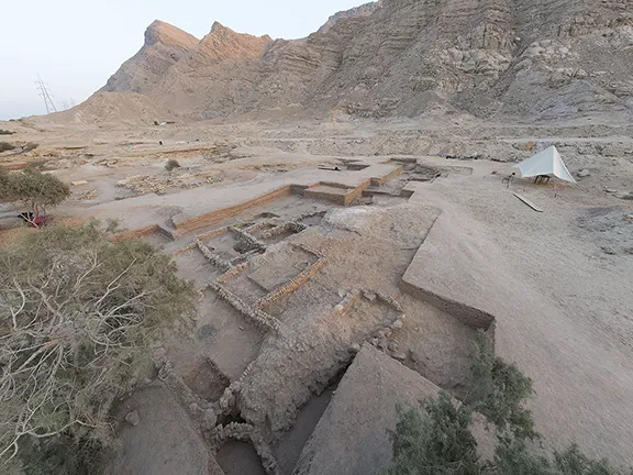 3: Egypt's Ayn Soukhna c 2500 - 1850 BC
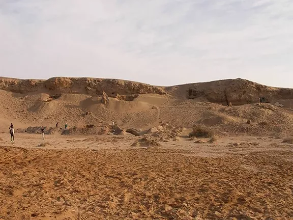 4: Egypt's Mersa/Wadi Gawasis c 2000 - 1500 BC
 5: Dana Island, Turkey c 800 BC - 700 AD