Ancient Mediterranean Shipyards and Harbours
Mersa/Wadi Gawasis: Egyptian Middle Kingdom shipyard c 2000 – c 1450 BC
Mersa Gawasis was an active port from the Middle Kingdom into the New Kingdom. Unlike Ayn Soukhna, it was used for long-distance voyages to the land of Punt. Discoveries of stelae and papyri at the site confirm its unique role as a primary port for these expeditions.
By Nick Nutter on 2025-09-2 | Last Updated 2026-01-20 | Ancient Mediterranean Shipyards and Harbours
This article has been visited 2,247 times

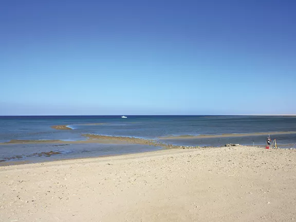
Mersa/Wadi Gawasis
Saww - The Maritime Gateway of the Middle Kingdom
Saww - The Maritime Gateway of the Middle Kingdom During the Old Kingdom, the harbours at Wadi al-Jarf and Ayn Soukhna primarily supported operations at the Sinai copper mines. In the Middle Kingdom, Egyptian expansion shifted southward. Approximately 25 kilometres south of present-day Safaga, at the mouth of Wadi Gawasis, lies the archaeological site of Mersa/Wadi Gawasis, historically known as Saww. This location served as a maritime base for long-distance trade expeditions to the Land of Punt (often referred to as God's Land) and the resource-rich region of Bia-Punt, particularly throughout the Middle Kingdom (circa 1985–1773 BC) and into the early New Kingdom period.
Unlike permanent coastal settlements, Saww operated as a seasonal "intermittent port," activated specifically by state directives to facilitate large-scale expeditions. During the 12th Dynasty, pharaohs such as Senusret I, Amenemhat II, and Amenemhat III invested significantly in this infrastructure to acquire valuable luxury goods including incense, ebony, ivory, and gold, that were essential for religious ceremonies and the enhancement of royal status.
The site remained hidden from modern history until 1976, when Abdel Monem A.H. Sayed of the University of Alexandria identified it based on scattered naval debris and inscriptions. However, it was the comprehensive excavations launched in 2001 by a joint Italian-American team, led by Kathryn Bard and Rodolfo Fattovich, that revealed the true scale of the operation. Their findings transformed our understanding of Pharaonic maritime capability, proving that the Egyptians were not merely river sailors but capable ocean navigators who engineered complex facilities to overcome the logistics of building, launching and maintaining a fleet of ships from a waterless desert coast.
The Archaeological Landscape of Mersa Gawasis
Mersa Gawasis is situated on a rugged fossil coral terrace overlooking the Red Sea, where ancient engineers modified the landscape to create a harbour complex. In contrast to the open shoreline of Wadi al-Jarf, the site's natural elevations enabled expedition leaders to structure the area into distinct zones, a harbour basin for vessel launching, an industrial sector for boat assembly and repairs, and a secure storage facility carved directly into the rock.
The Gallery Complex: A Naval Depot
The site's most prominent attribute is a sequence of eight artificial caves, or galleries, carved into the fossil coral cliff face. These galleries exhibit significant similarities to those discovered at Ayn Soukhna and Wadi al-Jarf, reflecting a standardised architectural approach to Pharaonic maritime infrastructure that persisted over several centuries.The Shrine of the Ankhu
In addition to the port's industrial infrastructure, the site also reveals insights into the psychological and spiritual aspects associated with these perilous journeys. Adjacent to the entrance of the galleries, researchers identified a ceremonial area featuring votive anchors and limestone stelae as prominent elements.The shrine functioned as a central site for ritual activities, likely dedicated to Min of Coptos, the deity associated with the Eastern Desert. At this location, sailors expressed gratitude for their safe return prior to undertaking the challenging journey back to the Nile.
The Temporary Settlement
In contrast to the permanent settlements established for workers at Giza or Deir el-Medina (Valley of the Kings and Valley of the Queens at Luxor), archaeological investigations at Wadi Gawasis have uncovered no traces of lasting residential structures. The evidence indicates that the site functioned as a temporary base, occupied exclusively during periods dedicated to organizing and concluding expeditions.
The workforce was accommodated not in permanent stone structures, but rather in provisional encampments adapted to the challenging environment. Archaeologists have discovered rings of stones and postholes carved into the fossil coral terraces overlooking the harbour, which indicate the foundations of tents or lightweight shelters. These structures, constructed from reed mats and animal hides, were intended to provide basic protection from the persistent wind and sun.
The absence of permanent infrastructure at the site was primarily due to its most significant limitation: the complete lack of fresh water. All potable water had to be transported by donkey train either from the Nile Valley or remote desert wells, creating substantial logistical challenges that made permanent habitation unfeasible. As a result, the settlement operated as a temporary base camp under demanding conditions. Archaeological findings such as hearths, ash deposits, and numerous ceramic bread moulds, mixed with industrial waste, demonstrate that workers resided, prepared meals, and slept adjacent to their workshops, relying entirely on supplies of water from the Nile for survival.
Dating the Site
Archaeologists used a multi-faceted approach to determine the length of time the site was in use, combining both textual and scientific methods.
Epigraphic Evidence
Inscriptions on stelae and papyri fragments were crucial. These texts not only detailed specific expeditions to Punt but also mentioned the reigns of pharaohs, from Senusret I to Amenemhat IV. This wide range of royal names established that the site was actively used throughout a significant portion of the Middle Kingdom, from the early 12th Dynasty to the late 12th/early 13th Dynasty. The inscriptions, found on stelae and other artifacts, provide the following details:
Senusret I (c 1971 to 1926 BC): The stela of the official Antefoker records an expedition to Bia-Punt during the reign of this pharaoh, marking an early use of the port.
Amenemhat II (c 1929 to 1895 BC): A stela from his reign, specifically dated to his 28th year, details a safe return from a Punt expedition.
Senusret II (c 1897 to 1878 BC): An inscribed stela found in a rock-cut chamber at the site records a voyage to Punt that occurred in the second year of his reign.
Senusret III (c 1878 to 1839 BC): Records associated with an official named Ankhu are linked to an expedition to Punt during his rule.
Amenemhat IV (c 1815 to 1806 BC): A recently discovered inscription mentions a Punt expedition during this pharaoh's reign, extending the known use of the harbour into the late Middle Kingdom.
Ceramic Analysis
The types of pottery found at the site were also key. By analysing the stylistic and typological sequences of the ceramics, archaeologists confirmed that the majority of the finds dated to the 12th and 13th Dynasties aligned with the dates the inscriptions provided. There were also smaller amounts of pottery that suggested the site may have been used as early as the late Old Kingdom and briefly into the early New Kingdom, indicating a longer, though intermittent, period of use.
Radiocarbon Dating
In addition to the artifact-based dating, archaeologists used radiocarbon dating on organic materials like wood, rope, and grass found at the site. These scientific tests provided independent confirmation of the Middle Kingdom dates, helping to establish a more precise chronological framework for the harbour's active period.
Research suggests that the Egyptians abandoned the harbour at Mersa/Wadi Gawasis around 3,500 years ago, which corresponds to the beginning of the New Kingdom (around 1500 BC). The reasons for its abandonment were likely twofold: a natural process of the bay silting up, and the reopening of other trade routes, potentially including riverine and land routes to Punt. The fall in sea level also contributed to the bay becoming less suitable as a harbour.
Do you enjoy my articles? For your reading pleasure, this website does not carry third party ads. You could help me write more articles by buying me a cup of coffee.
Building the Ships: The Stela of the Chamberlain Ankhu
One of the most notable findings at Wadi Gawasis is the limestone stela of the Chamberlain Ankhu. Unlike many inscriptions that contain general praises for the gods, Ankhu’s stela provides a comprehensive operational account, granting valuable insight into the administrative capabilities of the Middle Kingdom state. Dated to the 24th year of Senusret I's reign (c. 1947 BC), the inscription meticulously records details of an expedition to the mines of Bia-Punt with a level of precision comparable to modern supply chain documentation.
The inscription indicates that the fleet was not assembled on the remote Red Sea coast, which lacked timber and other necessary resources. Instead, construction took place at the royal dockyards in Coptos along the Nile. Upon completion and successful testing, the ships were disassembled into "ship kits," comprising individual planks and joinery connected using the characteristic Egyptian techniques of rope lashing and mortise-and-tenon joints.
Ankhu oversaw a workforce of 3,756 individuals tasked with transporting disassembled fleets across the Eastern Desert. These porters, scribes, and sailors moved ship timbers, anchors, rigging, and supplies over approximately 150 kilometers of arid terrain to the harbour at Saww.
Upon arrival at the Red Sea shore, the ships were reassembled, caulked, and launched. The stela records the fleet's successful return, emphasizing that the expedition concluded without the loss of any vessels, thereby demonstrating the effectiveness of this modular engineering approach.
Plank Dimensions: Hull planks that archaeologists discovered at Gawasis were substantial, with thicknesses of up to 22.5 cm, indicating the robustness required for open-sea conditions. Some thinner planks (2.5-4.2 cm) with small tenon coaks and paired ligature holes have also been found, showing potential similarities to frame fastenings on Greek laced boats.
Maintaining the Fleet: Evidence from the Galleries


Galleries at Mersa/Wadi Gawasis
One of the most notable findings at Wadi Gawasis is the limestone stela of the Chamberlain Ankhu. Unlike many inscriptions that contain general praises for the gods, Ankhu’s stela provides a comprehensive operational account, granting valuable insight into the administrative capabilities of the Middle Kingdom state. Dated to the 24th year of Senusret I's reign (c. 1947 BC), the inscription meticulously records details of an expedition to the mines of Bia-Punt with a level of precision comparable to modern supply chain documentation.
The inscription indicates that the fleet was not assembled on the remote Red Sea coast, which lacked timber and other necessary resources. Instead, construction took place at the royal dockyards in Coptos along the Nile. Upon completion and successful testing, the ships were disassembled into "ship kits," comprising individual planks and joinery connected using the characteristic Egyptian techniques of rope lashing and mortise-and-tenon joints.
Ankhu oversaw a workforce of 3,756 individuals tasked with transporting disassembled fleets across the Eastern Desert. These porters, scribes, and sailors moved ship timbers, anchors, rigging, and supplies over approximately 150 kilometers of arid terrain to the harbour at Saww.
Upon arrival at the Red Sea shore, the ships were reassembled, caulked, and launched. The stela records the fleet's successful return, emphasizing that the expedition concluded without the loss of any vessels, thereby demonstrating the effectiveness of this modular engineering approach.
Plank Dimensions: Hull planks that archaeologists discovered at Gawasis were substantial, with thicknesses of up to 22.5 cm, indicating the robustness required for open-sea conditions. Some thinner planks (2.5-4.2 cm) with small tenon coaks and paired ligature holes have also been found, showing potential similarities to frame fastenings on Greek laced boats. Maintaining the Fleet: Evidence from the Galleries The galleries, extending up to 20 meters in length, served a crucial economic purpose by preserving the fleet. Given that timber was both scarce and expensive in Egypt, cedar—often sourced from Lebanon via the so-called 'Byblos' ships—became an essential import. Prolonged exposure of vessels to intense sunlight and salt spray between expeditions would have led to rapid deterioration. To address this issue, crews returning from Punt meticulously dismantled their ships plank by plank, storing structural elements and necessary equipment, such as steering oars and rigging, within the galleries’ cool, stable environment. Archaeological excavations have also uncovered wooden cargo boxes inside these caves, some inscribed with the phrase, "Wonderful Things of Punt."
The excavation of the galleries provided concrete evidence of Egyptian maritime proficiency, which was previously inferred only from artistic depictions at Deir el-Bahari. Researchers identified ship components that demonstrate the use of advanced sewn-plank construction techniques. Shipbuilders employed mortise-and-tenon joints to align, rather than firmly fix, the cedar planks and reinforced the hull using transverse grass rope ligatures. This adaptable design allowed the vessels to endure the variable conditions of the Red Sea, thereby minimizing the likelihood of structural failure under stress.
A substantial number of timber fragments display considerable damage attributed to Teredo navalis, a marine shipworm. This biological evidence provides clear confirmation that the vessels were exposed to salt water over prolonged durations. Therefore, it is evident that these ships were specifically constructed for oceanic navigation, rather than being modified river barges suitable only for restricted coastal travel.
Analysis of artefacts found at the site give a deeper insight into how Wadi Gawasis worked.
Ship Recycling
The site shows extensive evidence of shipbreaking and the reworking of planks after sea voyages. Archaeologists have found thousands of pieces of wood debris, cordage, linen fragments, and ship parts with tool marks. Red paint markings on wood suggest inspection and identification of unsatisfactory timbers.
Evidence also suggests that the Egyptians reused timbers in other hulls or for architectural features on-site. Builders reinforced ramps within the gallery complex with cannibalized ship elements.
The Chandlery
Tools: Archaeologists found large copper-alloy tools such as adzes and chisels, as well as stone tools and wooden wedges, indicating the methods Egyptians used for dismantling and reworking ships.
Rigging: One of the most notable discoveries was the rope found in Gallery 5. The excavation team identified large coils of shipping rope, exceptionally well-preserved due to the arid environment. Several of these cables extend nearly 30 metres and are as thick as a human arm, clearly indicating the substantial rigging necessary to operate these heavy vessels on their journey south to the Horn of Africa.
Fastenings: Researchers have discovered fastenings that people cut and broke with tools. Additionally, archaeologists have found evidence for copper straps and ligatures that Egyptians used to reinforce lashing points in the planking. These were locked within channels using wooden wedges.
Rudder Blades and Anchors: Two wooden rudder blades for a steering oar and Egyptian-type stone anchors were among the initial finds.
Voyage to God’s Land: The Testimony of Ankhu
A fictional account of how it might have happened using factual data.
It was in the twenty-fourth year of the reign of my Lord, the King of Upper and Lower Egypt, Senusret, that the command was placed in my hands. The temples of the gods required the sweet smoke of incense, and the Treasury hungered for the gold of the south. My Lord the Pharaoh did not ask if the journey was possible; he merely commanded that it be done. As his Chamberlain, it was my duty to turn his divine will into reality.
Constructing our Fleet
The miracle began not at the sea, but in the dust of Coptos. In the royal dockyards, my shipwrights constructed our fleet from the finest cedar of Lebanon. We watched them sail upon the Nile, their hulls tight and their rigging proud. And then, by my order, we broke them into separate loads for our donkeys. We dismantled the pride of the navy until they were nothing but stacks of timber and coils of rope.
Our March to the Red Land
The march east into the Red Land was a trial by fire. I marshalled a force of 3,756 men—sailors, scribes, stone cutters, and soldiers—a human river flowing through the grey canyons of the Wadi Hammamat. We walked to the rhythm of the donkeys’ hooves, thousands of beasts laden with jars of Nile water, sacks of barley, and the disassembled bones of our fleet. The heat was a physical weight, pressing the breath from our lungs. For ten days we marched, knowing that to lose a water-carrier was to invite death, until finally, the shimmering horizon of the Great Black appeared.
Assembling our Fleet at the Edge of the World
Saww is a desolate place, a shelf of fossil coral lashed by the salt wind. Yet we made it a city. On the high terraces, my men raised shelters of reed mats to break the sun's glare. The air soon filled with the smoke of hearths and the comforting scent of bread rising in thousands of ceramic moulds, fuelling the bodies that would rebuild our wooden leviathans.
On the shore, the Herald Ameny directed the work. It was a task of immense precision. We laid out the cedar planks, matching the red paint marks we had inscribed at Coptos. We used no nails of copper or bronze to hold the sea at bay; such rigid things would snap in the ocean’s fury. Instead, my sailors hauled on massive grass ropes—cables as thick as a man’s arm—threading them through the timber channels. We lashed the hulls together until they hummed with tension, hammering in copper straps to bind the joints and caulking the seams with beeswax and papyrus. The masts were stepped and sails set on the yards. In weeks, we turned a pile of lumber into a living fleet.
Launching into the Sea of Punt
We launched into the unknown, our square sails catching the north wind. The voyage to Bia-Punt is not for the faint of heart. I recall the night the sky bruised purple and the winds turned against us. The waves rose like mountains, crashing over the gunwales, threatening to swallow us whole. It was then I understood the genius of our shipwrights. A rigid hull would have shattered under such violence. But our ships, held together by rope and tenon, flexed. The great cables supporting the mast groaned and stretched, allowing the cedar to ride the swells like a serpent. My helmsmen strained against the heavy steering oars, fighting the current, while below decks, the hulls remained tight. We survived the wrath of the sea for thirty days and thirty nights, and when the peaks of God’s Land finally rose from the mist, we wept.
Our Return Voyage
We conducted our trade on the foreign sands, exchanging the weapons of Egypt for the treasures of the south. When we turned our prows northward, our ships sat low in the water, heavy with a king’s ransom: heaps of myrrh resin, logs of dark ebony, ivory tusks, and raw gold. Most precious of all were the living myrrh trees, their roots carefully balled in baskets, destined for the garden of Amun. To my certain knowledge, this is the first time living trees have been taken from their place of birth to give pleasure to my lord Senusret in his palace gardens.
It was now that I realised the north winds were our enemy. Our sails could not hold the wind. The men toiled for hours on the long oars, fighting the very air itself. Exhausted after a day, we were often forced to take refuge overnight on the hostile coast, careful to avoid the reefs that would rip the bottoms from our hulls, as dangerous in their own way as the hippopotamus on our beloved Nile. We were tested for 80 days. I was forced to order water and bread rationing but my crews never lost heart, knowing they were doing the will of my lord and would be heroes on their return. Their tales will echo down the generations, from their children to their children’s children, until even the Great Pyramid of Khufu is as dust in the desert.
Despite the hazards we had faced, when we finally limped back into the harbour at Saww, we had lost not a single ship. Yet there was no rest. We stripped the vessels immediately, untying the great knots and cleaning the barnacles from the wood. We carried the planks up the stone ramps and laid them to rest in the cool darkness of the galleries we had hewn from the rock, sealing them alongside the great coils of rope, ready for the next generation.
Before we turned our backs on the sea to begin the long march home, I ordered a shrine erected near the caves. There, facing the waves that had failed to claim us, I dedicated my stela to Min of Coptos. I recorded for eternity that I, Ankhu, servant of Senusret, had gone to the ends of the earth and returned with the wonders of Punt.
The Last Hurrah: Hatshepsut’s Revival
Although the frenetic activity of the Middle Kingdom eventually waned, Wadi Gawasis was destined for one final, spectacular revival. By the early New Kingdom (c. 1470 BC), the harbour had largely fallen into disuse, yet it was here that Queen Hatshepsut chose to launch the most celebrated maritime venture in Egyptian history: her grand expedition to the Land of Punt.
For Hatshepsut, the choice of Wadi Gawasis was likely ideological as much as logistical. By reactivating the traditional Middle Kingdom gateway to "God’s Land," she connected her reign to the glorious achievements of ancestors like Senusret I, reinforcing her legitimacy as pharaoh. Archaeological evidence confirms this reactivation; excavations at the site uncovered distinct 18th Dynasty pottery styles and inscribed ostraca referencing the "Temple of Amun," directly linking the harbour to the religious administration of Thebes.
The scale of this operation was immense. The famous reliefs at her mortuary temple in Deir el-Bahari depict a fleet of five massive ships, far larger than their Middle Kingdom predecessors, equipped with hogging trusses to support their heavy hulls on the open ocean. These vessels returned laden with a king's ransom of trade goods: piles of myrrh resin, ebony logs, ivory tusks, and even thirty-one live myrrh trees with their roots preserved in baskets—the first recorded attempt at transplanting foreign flora in history.
The Abandonment of Wadi Gawasis
Following the magnificent revival under Hatshepsut in the early 15th century BC, activity at Mersa Gawasis rapidly diminished. Archaeological evidence indicates that by the mid-18th Dynasty, the site had effectively ceased to function as a major state-sponsored harbour, transitioning from a bustling logistical hub to a forgotten ruin.
The primary driver for this abandonment was likely environmental. The Red Sea coastline is geologically dynamic. Over centuries, coastal currents and wind-blown sand gradually silted up the lagoon that formed the natural harbour. As the water depth decreased, the sheltered basin eventually became inaccessible to the large, heavy-draught cargo vessels required for long-range Punt expeditions, forcing Egyptian admirals to seek alternative locations.
Simultaneously, Egypt’s strategic horizons shifted during the imperial age of the New Kingdom. Later pharaohs, such as Ramesses II in the 19th Dynasty, reorganized maritime infrastructure. The state revitalised northern ports like Ayn Soukhna for operations across the Gulf of Suez and developed harbours further south to Quseir (Myos Hormos) and eventually Suakin, both of which offered better wind conditions for the return journey from the southern Red Sea. The arduous 150-kilometre desert trek from Coptos to Gawasis was no longer the most efficient route.
Ultimately, the expansive complex at Wadi Gawasis was surrendered to the desert. Rockfalls from the unstable cliffs and drifting sands sealed the entrances to the galleries, entombing the coils of rope, steering oars, and votive stelae in a state of near-perfect preservation. The great "Maritime Gateway" of the Middle Kingdom vanished from human memory, holding its secrets safe until its rediscovery in 1976.
References
Bard, Kathryn A., and Rodolfo Fattovich. "Recent Excavations At The Ancient Harbor Of Saww (Mersa/Wadi Gawasis) On The Red Sea." ResearchGate.
Bard, Kathryn A., and Rodolfo Fattovich. "Spatial Use of the Twelfth Dynasty Harbor at Mersa/Wadi Gawasis for the Seafaring Expeditions to Punt." ResearchGate.
Bard, Kathryn A. (2010). "Boston University Arts & Sciences" magazine. This article discusses the discovery of the caves, and the significance of the rope finds.
Bard, K. A., & Fattovich, R. (Eds.). (2018). Seafaring Expeditions to Punt in the Middle Kingdom: Excavations at Mersa/Wadi Gawasis. Brill. https://doi.org/10.1163/9789004368507
Carannante Alfredo (2014) Marine Resources Exploitation at Mersa/Wadi Gawasis (Red Sea, Egypt). The Harbour of the Pharaohs to the Land of Punt.
Fattovich, Rodolfo & Bard, Kathryn A. (2010). "MERSA/WADI GAWASIS 2009-2010". This geological and archaeological report discusses the site's environment and the details of the finds, including those from the caves.
Manzo A. et al. (2024) Back to the Harbour of the Pharaohs to the Land of Punt; New Archaeological Investigations at Mersa/Wadi Gawasis
Naville, E. (1898). The Temple of Deir el Bahari: Part III. End of the Northern Half and Southern Half of the Middle Platform. Egypt Exploration Fund.
Sayed, A. M. A. H. (1977). Discovery of the Site of the 12th Dynasty Port at Wadi Gawasis on the Red Sea Shore. Revue d'Égyptologie, 29, 138–178.
Sayed, A. M. A. H. (1978). The Recently Discovered Port on the Red Sea Shore. The Journal of Egyptian Archaeology, 64, 69–71.
Tallet, P. (2012). Ayn Sukhna and Wadi el-Jarf: Two newly discovered pharaonic harbours on the Suez Gulf. British Museum Studies in Ancient Egypt and Sudan, 18, 147–168.
Tallet, P. (2012). Ayn Sukhna and Wadi el-Jarf: Two newly discovered pharaonic harbours on the Suez Gulf. British Museum Studies in Ancient Egypt and Sudan, 18, 147–168.
Ward, C., & Zazzaro, C. (2010). Evidence for Pharaonic Seagoing Ships at Mersa/Wadi Gawasis, Egypt. International Journal of Nautical Archaeology, 39(1), 27–43. https://doi.org/10.1111/j.1095-9270.2009.00244.x
Do you enjoy my articles? For your reading pleasure, this website does not carry third party ads. You could help me write more articles by buying me a cup of coffee.
 1: Egypt's Wadi al-Jarf c 2600 - 2560 BC
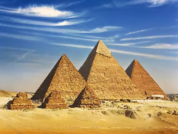 2: Egypt's Ro-She Khufu 2580 - 2500 BC
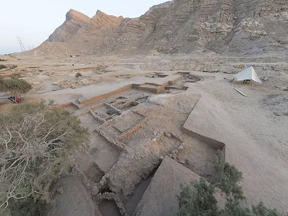 3: Egypt's Ayn Soukhna c 2500 - 1850 BC
 5: Dana Island, Turkey c 800 BC - 700 AD