Surprising Survivors

Surviving the Bronze Age Collapse: The Epidaurus Model

Drawing on decades of archaeological research and recent fieldwork, this article examines how the ancient Greek city-state (polis) of Epidaurus survived the catastrophic Late Bronze Age collapse (c. 1200 BCE). While earlier scholarship viewed this era as a “Dark Age,” the survival of Epidaurus —achieved by pairing an agile coastal harbour on the Saronic Gulf with a decentralised inland sanctuary at Mount Kynortion —proves the collapse was a transformative process. The highly centralised, rigid palace economies, such as those at Mycenae and Tiryns in the Argolid , were fragile; their hyper-reliance on complex, international supply chains for bronze-making materials proved fatal when those networks failed.

By Nick Nutter | Published: | Updated:

Visited 30 times

Surviving the Bronze Age Collapse: The Epidaurus Model - Epidaurus in the 21st century CE
Epidaurus in the 21st century CE

Surviving the Collapse: Epidaurus, Anti-Fragility, and the Maritime Pivot in the Early Iron Age

Author’s Note: Nick Nutter brings over 25 years of firsthand archaeological exploration across the Mediterranean to this analysis. The topographical observations regarding the coastline of Epidaurus (37°38′N 23°09′E) were verified during direct site fieldwork in the Argolid peninsula (eastern Peloponnese, modern Greece) in early 2026.

Drawing on decades of archaeological research and recent fieldwork, this article examines how the ancient Greek city-state (polis) of Epidaurus survived the catastrophic Late Bronze Age collapse (c. 1200 BCE). While earlier scholarship viewed this era as a “Dark Age,” the survival of Epidaurus—achieved by pairing an agile coastal harbour on the Saronic Gulf (Aegean Sea) with a decentralised inland sanctuary at Mount Kynortion (elevation 350m)—proves the collapse was a transformative process. The highly centralised, rigid palace economies, such as those at Mycenae (37°43′N 22°45′E) and Tiryns (37°35′N 22°47′E) in the Argolid, were fragile; their hyper-reliance on complex, international supply chains for bronze-making materials proved fatal when those networks failed (Osborne, 2009). Communities that survived did so by reducing dependence on highly centralised institutions and by developing more flexible social, economic, and religious networks.

Epidaurus, located on the eastern side of the Argolid and facing the Saronic Gulf, offers a particularly instructive case. Its post-palatial development combined two complementary strategies: an inland religious centre that preserved cultural continuity and a coastal harbour that enabled participation in agile maritime networks. This article argues that the emergence of Epidaurus as an early polis depended on the productive tension between these two poles.

How the 1200 BCE Bronze Age Collapse Affected Epidaurus

To understand the survival of Epidaurus, we must first examine how this specific coastal community was impacted by the systemic collapse of the Late Bronze Age Mycenaean palatial system around 1200 BCE.

Climate Shock: The 12th Century BCE Mega-Drought in the Argolid

The population of the Argolid did not just decrease; it imploded. Archaeological surveys indicate that between the 13th and 11th centuries BCE, the number of occupied settlements in the wider region plummeted by an estimated 70% to 90% (Dickinson, 2006). This was not a managed decentralisation; it was a demographic catastrophe.

The Climate Driver: Modern paleoclimatology, particularly pollen core and sediment analyses from the Eastern Mediterranean basin, strongly indicates a multi-century mega-drought beginning around 1200 BCE (Drake, 2012).

The Reality in Epidaurus: The specialised Mycenaean agricultural system, which relied on mass-producing grain and olive oil to feed the centralised palaces, failed completely under prolonged drought conditions. For the average farmer in Epidaurus, this environmental collapse meant immediate famine. The continuous animal sacrifices at the peak sanctuary of Mount Kynortion should not be viewed as triumphant civic gatherings; initially, they were likely desperate, traumatised pleas to the divine by starving survivors begging for rain and agricultural relief.

The Death of Maritime Trade

The International Network Ceased: The grand Bronze Age maritime trade network, which transported copper from Cyprus (35°N 33°E), tin from modern-day Afghanistan (via the Levant coast), and luxury goods from New Kingdom Egypt, completely collapsed (Cline, 2014). The massive, state-sponsored Mycenaean merchant fleets vanished from the sea. For a coastal community situated on the Saronic Gulf, the sudden emptiness of the maritime horizon would have been a terrifying indicator of systemic societal failure.

Local Coaster Trade: The sea did not become entirely unnavigable, but it became highly dangerous. Trade was reduced to local, opportunistic coastal hopping. With the palatial navies gone, piracy became rampant. The subsequent Epidaurian maritime pivot—trading iron goods approximately 50 kilometres across the gulf—did not happen overnight. There was likely a century or more where the harbour was reduced to subsistence fishing and fearful, short-distance bartering.

The Redistribution of a Population

The Eastern Mediterranean in the 12th century BCE was overwhelmed with climate refugees, displaced mercenaries, and uprooted communities seeking habitable land.

The Myth of the 'Dorian Invasion': Older historical models claimed a violent race of 'Dorians' swept down from the north and burned the Mycenaean palaces. Modern archaeology firmly rejects this singular, violent invasion narrative. The palatial centres collapsed primarily due to interconnected systemic failures, including climate shocks, seismic activity, and economic fragility (Osborne, 2009).

The Migration Reality: Instead of a sudden invasion, there was a chaotic, prolonged era of regional migration. Facing starvation in the Argolid, many Mycenaean Greeks became refugees, fleeing east across the sea to Cyprus and the Ionian coast (western Anatolia, modern-day Turkey) (Hall, 2007).

The Dorian Influx at Epidaurus: Conversely, as the palatial populations died off or fled, pastoralist groups from the Pindus Mountains (northern Greece) and western regions of Epirus (northwestern Greece) slowly migrated into the demographic vacuum over several generations. These were the Doric-speaking peoples. Epidaurus emerged from the subsequent Early Iron Age identifying as a strictly Dorian polis. The trauma here was one of profound demographic upheaval: the surviving Mycenaean Epidaurians had to assimilate, intermarry, or conflict with these incoming nomadic Doric populations to eventually forge their new Iron Age identity.

Surviving the Bronze Age Collapse: The Epidaurus Model - The Little Theatre Epidaurus
The Little Theatre Epidaurus

The Geography of Iron Age Epidaurus

The nature of the polis that emerged during the Iron Age at Epidaurus, and other poleis in the Argolid and the rest of the Peloponnese, was determined by its geography.

Coastal Topography and the Harbour System

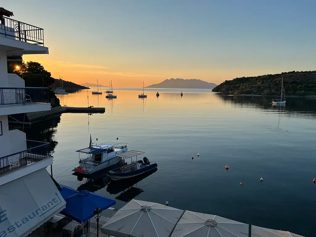
The maritime centre of ancient Epidaurus lay in the northern bay, close to the modern marina of Palaia Epidavros (37°38′N 23°09′E) on the eastern coast of the Peloponnese. In the Late Bronze Age, this inlet functioned as a protected natural anchorage. Its position on the Acte peninsula (northeastern Peloponnese) sheltered shallow-draft vessels from prevailing Aegean winds, allowing them to be drawn directly onto the beach without the need for substantial harbour works (Tartaron, 2013).

After c. 1200 BCE, as palatial exchange systems contracted, the same coastal geography became the basis for a more active maritime orientation. By the Iron Age and Classical periods, the northern bay had developed into a formal harbour with breakwaters and quays. Severe tectonic subsidence along the eastern Peloponnese has left parts of this harbour infrastructure submerged near the Nisi peninsula (a small promontory extending into the Saronic Gulf) (Flemming, 1968).

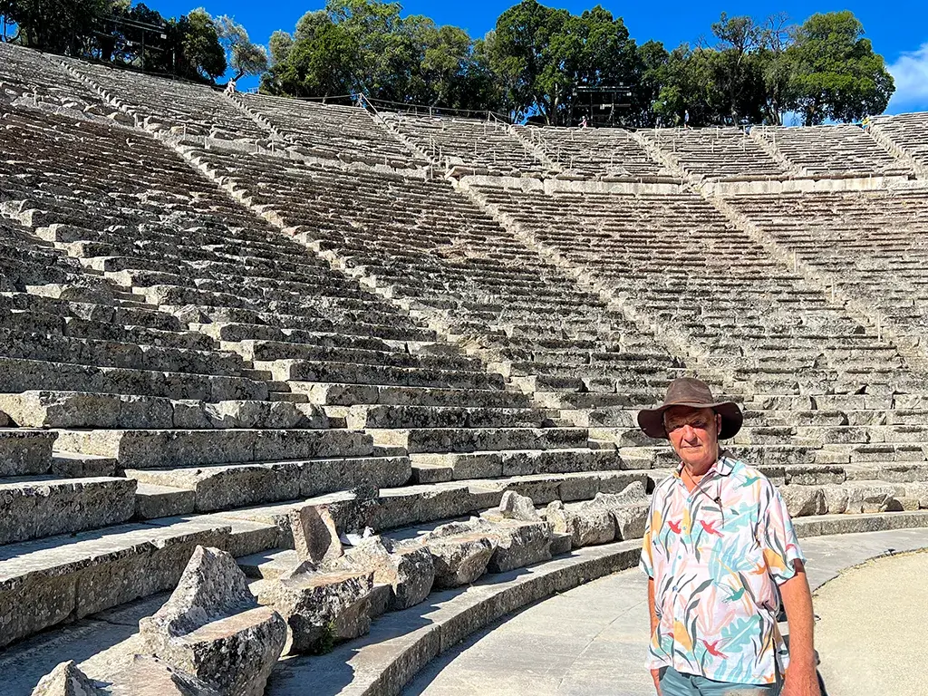
Civic Space: The Nisi Peninsula and the 4th Century BCE Little Theatre

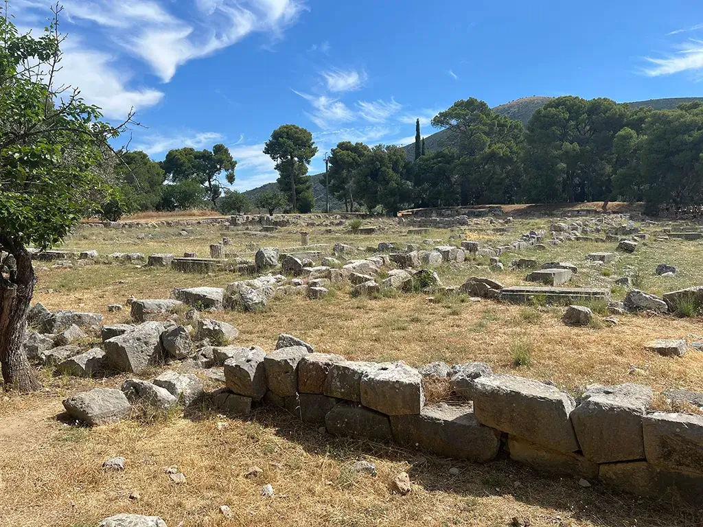
The Nisi peninsula separated the northern harbour from the southern bay and formed the acropolis and civic nucleus of the coastal polis. Classical defensive walls protected the headland, the harbour, and the adjacent agora; surviving polygonal masonry on the slopes preserves traces of this fortified civic landscape (Tomlinson, 1983).

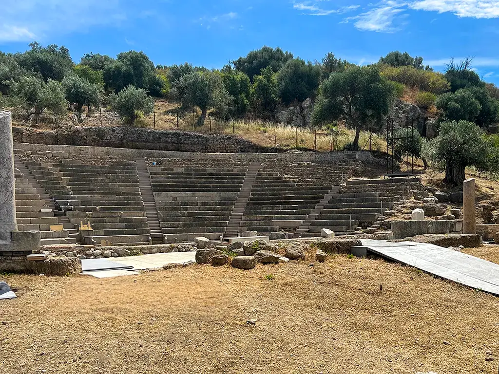
The Little Theatre of Ancient Epidaurus, built into the western slope of the headland, was originally constructed in the fourth century BCE, although it was later modified in the Roman period. Unlike the better-known theatre at the inland Sanctuary of Asclepius (37°35′N 23°04′E), this coastal theatre served the civic community of the harbour town and was dedicated to Dionysus rather than Asclepius (Tomlinson, 1983).

Its westward orientation is significant. The theatre faced inland towards the agora, placing civic performance within the inhabited and administrative space of the port. The arrangement emphasises that, by the 4th century BCE, the harbour was not merely an economic facility but an integrated civic environment.

Debunking the “Sunken City”: The 2nd Century CE Roman Villa at Agios Vlasios

South of the Nisi headland, in the Bay of Agios Vlasios (south of the modern port) near modern Kalymnios and Gliati beaches, lie shallow submerged remains frequently promoted by tourism boards as the “Sunken City” of ancient Epidaurus. However, as my recent underwater fieldwork and direct observation of the site confirm, this label is highly misleading. The visible remains submerged in two metres of water are strictly the foundations of a 2nd-century CE Roman villa maritima, built nearly a millennium after the Iron Age harbour.

The structures date principally to the Roman period, when improved security under the Pax Romana encouraged elite settlement directly on the coast. The paved floors, domestic foundations, and massive pithoi (storage vessels) visible today are consistent with a sprawling agricultural estate dedicated to production and export, rather than the earlier civic harbour of the Greek polis (Kritzas, 1971; Whittlesey, 1970). The heavy ashlar blocks of the true ancient Greek harbour lie further north, submerged beneath modern maritime activity and tectonic subsidence.

The Inland Sanctuary and Cult Continuity

The Sanctuary of Asclepius lay roughly 15 kilometres inland from the harbour, in a fertile valley framed by Mount Kynortion and Mount Titthion (elevation approx. 400m). Its location separated the community’s principal religious centre from the exposed maritime zone, while still allowing it to remain connected to coastal wealth and pilgrimage.

This inland setting gave Epidaurus an ideological anchor. Whereas the harbour was open to exchange, risk, and innovation, the sanctuary was embedded in the agricultural hinterland and shielded by mountainous terrain. Such spatial separation helped distribute risk across the territory of the polis (de Polignac, 1995).

The sanctuary’s importance also lay in its cultic continuity. Religious activity did not begin suddenly with the Classical cult of Asclepius. Earlier ritual practice centred on Mount Kynortion, where excavations have revealed an open-air ash altar associated with Apollo Maleatas and earlier cult traditions. Stratified deposits of ash and votive material indicate continuity from the Late Bronze Age through the Early Iron Age and into the Archaic period (Lambrinoudakis, 1981).

This evidence complicates any simple model of cultural rupture after the collapse of the palaces. While nearby palatial centres declined or were destroyed, local communities continued to mark sacred space, make offerings, and reproduce collective identity through ritual. From the sixth century BCE onwards, the cult expanded into the valley and became increasingly associated with Asclepius, eventually producing the monumental healing sanctuary of the Classical period (Tomlinson, 1983).

The Sacred Way: The 15-Kilometre Artery Connecting Port and Sanctuary

The relationship between the coastal harbour and the inland sanctuary was materialised in a 15-kilometre processional road conventionally known as the Sacred Way. Walking the modern, rugged terrain between Palaia Epidavros and the sanctuary valley today, the strategic genius of this spatial separation becomes obvious. This physical artery linked the harbour town with the inland sanctuary, enabling the movement of pilgrims, offerings, and prestige goods across the territory of the polis.

Although much of the original route has been obscured by later agriculture and erosion, its existence is supported by textual, architectural, and topographical evidence. The most definitive textual proof comes from the 2nd-century CE geographer Pausanias. In his Description of Greece (Book 2.26), he explicitly records his journey from the coastal city of Epidaurus inland to the sanctuary, noting specific landmarks such as the precinct of Asclepius and statues along the route.

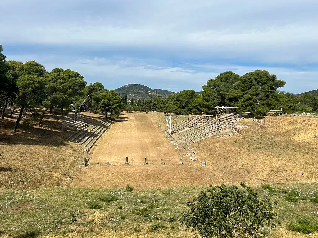
At the Sanctuary of Asclepius itself, archaeologists excavated the monumental Propylaia (gateway), constructed in the late 4th or early 3rd century BCE. This grand entrance is located on the northern edge of the sanctuary and is oriented outwards to receive the processional road arriving through the mountain passes from the coastal port (Tomlinson, 1983). Finally, field surveys navigating the ravines between the coast and Mount Kynortion have identified fragmentary remnants of the ancient road network. These include deep wheel-ruts cut into the bedrock in the steeper mountain passes, as well as segments of ancient retaining walls designed to support the road (Bintliff, 2012).

Settlement, Governance, and the Decentralised Polis

The social geography of early Epidaurus should not be imagined as a dense urban centre surrounded by empty countryside. Like many early Greek poleis, it was better understood as a territorial network composed of a harbour, sanctuary, agricultural land, and dispersed villages.

After the collapse of the Mycenaean palatial order, population and authority were distributed across the chora (agricultural hinterland) in kōmai (villages or hamlets), rather than concentrated in a single palace. This arrangement reduced the danger of systemic failure: crop loss, local conflict, or political instability in one part of the territory did not necessarily endanger the whole community (Bintliff, 2012).

Politically, this landscape favoured collective aristocratic leadership rather than palatial monarchy. The Mycenaean wanax (centralised king) gave way to local basileis, best understood not as absolute kings but as leading aristocratic landholders whose authority depended on consensus, reputation, and control of resources.

The early polis therefore developed through a process known as synoikismos (literally "living together"), not necessarily by physically moving the population into an urban centre, but by drawing scattered communities into shared institutions: a common harbour, a common sanctuary, and an emerging civic framework (Osborne, 2009). Councils of elders and assemblies of adult male citizens provided mechanisms for negotiation and collective decision-making, limiting the concentration of power in a single fragile node (Hall, 2007; Morris, 1987).

Maritime Networks and Economic Adaptation

The harbour transformed the economic possibilities of Epidaurus. As land-based palatial routes weakened, the Saronic Gulf offered a smaller and more flexible maritime arena linking Epidaurus with Aegina (an island in the Saronic Gulf, 37°44′N 23°29′E), Megara (38°00′N 23°20′E), Athens (Attica, 37°58′N 23°43′E), and the wider Aegean (Tartaron, 2013).

This maritime orientation also altered the social balance within the polis. Aristocratic status had traditionally rested on landholding, but harbour activity created opportunities for merchants, shipbuilders, and sailors to accumulate wealth outside the older agrarian hierarchy. The resulting tension between landed and maritime wealth contributed to the longer-term evolution of more participatory civic institutions in the Archaic and Classical periods (Snodgrass, 1980).

The shift from bronze to iron further reduced dependence on the disrupted copper and tin routes of the Bronze Age. Evidence for iron at Epidaurus is primarily artefactual: early iron weapons and dress pins have been recovered from the sanctuary deposits on Mount Kynortion (Lambrinoudakis, 1981). However, direct evidence for local smelting has not been identified, so claims for an Epidaurian iron industry should remain cautious. Having said that, local iron forging would have been vital for producing the agricultural tools necessary to maintain the "Epidaurus with its vineyards" autarky that Homer praised. Iron was not just for war; it was the metal of agricultural survival when the bronze trade died.

Imported Protogeometric and Geometric pottery with Attic (from the region of Attica) and Euboean (from the island of Euboea, 38°30′N 23°50′E) affinities nevertheless indicates that the harbour was connected to exchange systems across the gulf and beyond (Morris, 2000). Epidaurus did not simply retreat into local subsistence; it used its coastal position to participate in a reconfigured post-palatial economy.

Surviving the Bronze Age Collapse: The Epidaurus Model - The Sanctuary of Asclepius, 10 km north of Episaurus
The Sanctuary of Asclepius, 10 km north of Episaurus

The Bipartite Polis

The distinctive strength of Epidaurus lay in the relationship between its two principal zones: the coastal harbour and the inland sanctuary. The former was open, commercial, and exposed to the risks and opportunities of maritime exchange on the Saronic Gulf; the latter was stable, sacred, and embedded in the agricultural landscape of the inland valleys.

This spatial division produced a resilient civic ecology. Wealth generated through the harbour could be channelled inland through ritual dedications at the Sanctuary of Asclepius, while the sanctuary provided a shared symbolic framework that helped bind dispersed communities and maritime actors into a common civic identity (de Polignac, 1995). Epidaurus thus exemplifies a bipartite model of early polis formation: decentralised, territorially distributed, and capable of absorbing external shocks.

Surviving the Bronze Age Collapse: The Epidaurus Model - The Stadium at the Sanctuary of Asclepius
The Stadium at the Sanctuary of Asclepius

Epidaurus in Regional and Literary Context

The regional significance of Epidaurus is reflected in both literary tradition and later interstate activity. In the Iliad, Epidaurus appears in the “Catalogue of Ships” (a meticulous rollcall of the Greek forces sailing to Troy [Hisarlik, modern Turkey, 39°57′N 26°14′E]), within the contingent commanded by the Argive hero Diomedes:

“And those that held Argos (37°38′N 22°43′E), and Tiryns of the great walls... Troezen (37°30′N 23°22′E), Eïones, and Epidaurus with its vineyards, and the Achaean youths that held Aegina and Mases (modern Kilada region); these were led by Diomedes of the loud war-cry...” (Homer, Iliad 2.559–567)

The epithet “Epidaurus with its vineyards” points to the agricultural base of the polis. Viticulture requires long-term stability and investment in the land, reinforcing the idea of a resilient, rooted community. Its association with Diomedes and Argos reflects the continuing geopolitical pressure exerted by the Argive plain. Epidaurus’ later maritime orientation can therefore be read partly as a strategy for maintaining autonomy against stronger land-based neighbours.

Maritime Alliances and the Aeginetan Challenge

By the Archaic period, about 800 BCE, Epidaurus participated in wider Saronic networks such as the Calaurian Amphictyony, of which Epidaurus was a founding member, a religious and political association centred on the Sanctuary of Poseidon on Calauria (modern Poros, 37°31′N 23°28′E). Ancient testimony associates the league with communities including Epidaurus, Athens, Aegina, Hermione (37°23′N 23°15′E), Prasiai (Leonidio coast, 37°09′N 22°51′E), Nauplia (37°34′N 22°48′E), and the Boeotian Minyans (central Greece) (Kelly, 1966).

This was a mutual protection pact for maritime trade. By allying with other coastal poleis, Epidaurus secured its shipping lanes in the Saronic Gulf against piracy and land-based threats from Argos.

The Colonisation and Revolt of Aegina (c. 7th Century BCE)

The relationship with Aegina illustrates the instability generated by maritime success. Aegina, originally colonised by the Epidaurians, and visible from the Epidaurian harbour, eventually developed into a powerful naval and commercial rival. Herodotus reports that the Aeginetans revolted against Epidaurian control and raided the Epidaurian coast, seizing sacred olive-wood images of Damia and Auxesia (Herodotus, Histories 5.83).

The episode is revealing because it joins religious symbolism, agricultural identity, and maritime violence. The stolen images belonged to agrarian cult, yet the conflict was driven by naval competition. Aegina’s rise shows that the same networks that enabled Epidaurus to flourish also generated new forms of rivalry within the Saronic world.

The Greater Asclepieia: Epidaurus’s Pan-Hellenic Festival

The Greater Asclepieia of Epidaurus was a major pan-Hellenic athletic and musical festival held every four years (penteteris) at the inland Sanctuary of Asclepius. While it lacked a precise founding date like the Olympics, the earliest known athletic victories occurred around 530 BCE. The games were famous enough to be immortalised in the victory odes of the lyric poet Pindar in the 480s BCE, and they reached their monumental, architectural peak in the 4th century BCE (Pindar, 1997).

The establishment of the Greater Asclepieia festival was a geopolitical masterstroke that illustrates Epidaurus’s maritime 'network pivot'. While the inland sanctuary of Asclepius began as a regional cult centre following the Bronze Age collapse, by the Classical era, the Epidaurian basileis had transformed it into an international powerhouse. Months before the games began, Epidaurus dispatched sacred heralds (spondophoroi) across the Mediterranean via their coastal shipping routes. These heralds announced a sacred truce (ekecheiria), guaranteeing safe maritime passage for athletes, pilgrims, and wealthy spectators. This truce temporarily neutralised the volatile geopolitics of the era, allowing Epidaurus to fully activate its harbour and safely funnel vast international wealth up the Sacred Way into its mountainous interior (Dillon, 1997).

The true brilliance of the Asclepieia lay in its calculated integration with the prestigious Panhellenic 'Crown' games (the Periodos). Epidaurus did not attempt to directly compete with the ancient, established prestige of Olympia (37°38′N 21°37′E) or Delphi (38°28′N 22°30′E). Instead, it practised pure maritime opportunism. The Epidaurians strategically synchronised their calendar so that the Greater Asclepieia commenced exactly nine days after the conclusion of the Isthmian Games at Corinth (37°54′N 22°52′E) (Miller, 2004). This scheduling hijacked the existing flow of international traffic. Elite athletes, trainers, and wealthy tourists finishing their events at the Corinthian isthmus could simply board a ship, execute a short, safe coastal sail down the Saronic Gulf to the Epidaurian harbour, and march inland to compete again. By embedding their festival in the slipstream of the Isthmian Games, Epidaurus guaranteed a massive, captive audience of the Mediterranean's wealthiest consumers.

Once the procession reached the inland sanctuary, the festival programme reflected the holistic Greek philosophy of healing, physically enacting the wealth and sophistication of the city-state. The competitions were divided into two main spheres. The gymnikos agon (naked athletic contests) took place in the sanctuary’s massive stadium, featuring violent combat sports like the pankration alongside sprints and the pentathlon. Crucially, as a 'Chrematitic' (prize) festival, the Asclepieia rewarded its victors with substantial material wealth, unlike the symbolic wreaths of the Crown games, which further incentivised elite participation (Kyle, 2015).

Simultaneously, the magnificent 4th-century BCE Theatre of Epidaurus at the Asclepieion (not to be confused with the coastal Little Theatre constructed on the Nisi peninsula) hosted the mousikos agon (musical and dramatic contests). Here, the finest actors, rhapsodes, and musicians in the Greek world competed, providing therapeutic entertainment for the thousands of patients seeking cures.

The Asclepieia was thus the ultimate expression of the bipartite polis: it leveraged the agile, outward-facing networks of the coastal harbour to enrich and glorify the enduring, anti-fragile sanctuary in the hills.

Surviving the Bronze Age Collapse: The Epidaurus Model - The 4th C BCE Theatre at the Sanctuary of Asclepius
The 4th C BCE Theatre at the Sanctuary of Asclepius

Conclusion

Epidaurus did not merely endure the aftermath of the Bronze Age collapse; it reorganised itself through a durable combination of territorial decentralisation, cult continuity, and maritime adaptation. Its inland sanctuary preserved a shared religious identity rooted in pre-Classical practice, while its harbour opened the community to exchange, mobility, and new sources of wealth. The resulting polis was neither a survival of the Mycenaean palace system nor a purely urban invention. It was a distributed civic organism, structured around complementary inland and coastal institutions. In this sense, Epidaurus offers a compelling model for understanding how early Greek communities transformed systemic collapse into new forms of resilience.

Author’s Note

As we shall see in future articles, there is a remarkable similarity not only between the geography of these poleis but also how they functioned and, critically, converted hostile intent for resources into periodic competitions between heroes.

References

  • Bintliff, J. (2012) The Complete Archaeology of Greece: From Hunter-Gatherers to the Year 2000. Oxford: Wiley-Blackwell.
  • Cline, E. H. (2014) 1177 B.C.: The Year Civilization Collapsed. Princeton: Princeton University Press.
  • de Polignac, F. (1995) Cults, Territory, and the Origins of the Greek City-State. Translated by J. Lloyd. Chicago: University of Chicago Press.
  • Dickinson, O. (2006) The Aegean from Bronze Age to Iron Age: Continuity and Change Between the Twelfth and Eighth Centuries BC. London: Routledge.
  • Dillon, M. (1997) Pilgrims and Pilgrimage in Ancient Greece. London: Routledge.
  • Drake, B. L. (2012) 'The influence of climatic change on the Late Bronze Age Collapse and the Greek Dark Ages', Journal of Archaeological Science, 39(6), pp. 1862-1870.
  • Flemming, N. C. (1968) ‘Holocene Earth Movements and Eustatic Sea Level Change in the Peloponnese’, Nature, 217(5133), pp. 1031–1032.
  • Hall, J. M. (2007) A History of the Archaic Greek World: ca. 1200–479 BC. Oxford: Blackwell.
  • Herodotus (2003) The Histories. Translated by A. de Sélincourt. London: Penguin Classics.
  • Homer (2003) The Iliad. Translated by E. V. Rieu. London: Penguin Classics.
  • Kelly, T. (1966) ‘The Calaurian Amphictiony’, American Journal of Archaeology, 70(2), pp. 113–121.
  • Kritzas, C. V. (1971) ‘Palaia Epidavros’, Archaiologikon Deltion, 26 (Chronika), pp. 84–85.
  • Kyle, D. G. (2015) Sport and Spectacle in the Ancient World. 2nd edn. Chichester: Wiley Blackwell.
  • Lambrinoudakis, V. (1981) ‘Remains of the Mycenaean Period in the Sanctuary of Apollo Maleatas’, in R. Hägg and N. Marinatos (eds) Sanctuaries and Cults in the Aegean Bronze Age. Stockholm: Svenska Institutet i Athen, pp. 59–65.
  • Miller, S. G. (2004) Ancient Greek Athletics. New Haven: Yale University Press.
  • Morris, I. (1987) Burial and Ancient Society: The Rise of the Greek City-State. Cambridge: Cambridge University Press.
  • Morris, I. (2000) Archaeology as Cultural History: Words and Things in Iron Age Greece. Oxford: Blackwell.
  • Osborne, R. (2009) Greece in the Making 1200–479 BC. 2nd edn. London: Routledge.
  • Pindar. Nemean Odes. Translated by W. H. Race (1997). Loeb Classical Library 485. Cambridge, MA: Harvard University Press.
  • Snodgrass, A. M. (1980) Archaic Greece: The Age of Experiment. London: J. M. Dent & Sons.
  • Tartaron, T. F. (2013) Maritime Networks in the Mycenaean World. Cambridge: Cambridge University Press.
  • Tomlinson, R. A. (1983) Epidauros. London: Granada.
  • Whittlesey, J. H. (1970) ‘Tethered Balloon for Archaeological Photos’, Photogrammetric Engineering, 36(2), pp. 181–186.

Enjoying the fast, clean reading experience?

Discover how I partnered with an AI to rescue this outdated site from technical debt and hit perfect 100/100 Lighthouse scores. Legacy Reloaded is the ultimate guide to modernising old code without losing your mind.

Location Map

Location Map